Utajärvi is a northern Finnish municipality where the Oulujoki river corridor, broad peatlands and the Ice Age forms of Rokua meet. It had 2,399 residents on 31 December 2025; this is the population of the entire municipality, not only its church village. The compact centre is a useful starting point, but the area's strongest experiences are spread between the church and local-history museum, the Rokua landscape to the southeast, and the quieter protected bogs toward the north.
A centre shaped by church, river and route
The wooden church, completed in 1762 by builder Heikki Väänänen, is a rare Pohjanmaa-style block-pillar church. Its late nineteenth-century Gothic revival alterations were reversed in a 1970 restoration that returned the exterior to its red-ochre appearance. The churchyard also holds a bell tower, memorials and the local-history museum, housed in an old grain store recorded from at least 1874. The museum's collection includes roughly 300 catalogued objects and a covered rapids boat built in an early twentieth-century style. It usually opens during the summer local-heritage week or by arrangement, so check before visiting.
A short culture trail links sites around the centre. The Kivipuisto rock garden, founded in 1993, uses more than fifty large rock samples to explain Finland's bedrock. Its oldest specimen is Siurua gneiss, dated at about 3.5 billion years. At the old market square, the bronze Roomari statue recalls the work of a ferryman. These stops give a visitor a small-scale introduction to geology and river transport before heading into the wider landscape.
Rokua, Olvassuo and the working countryside
Rokua National Park lies within the municipality and forms part of the wider Rokua UNESCO Global Geopark, whose linked landscapes extend across Rokua, the Oulujoki valley and Lake Oulujärvi. The dunes, ridges and kettle ponds were shaped by retreating ice and the former shoreline. Marked walking and cycling routes, the Pookivaara observation tower and nearby accommodation make the area suitable for more than a brief roadside stop. Routes and facilities can change with weather and maintenance, so check trail notices before setting out.
North of the centre, Olvassuo is a large protected mire complex with bog, river and forest habitats. The municipality points visitors to marked nature paths, lean-to shelters and bird towers in both its southern and northern sections. At Valkeisjärvi in Sanginkylä, facilities listed by the municipality include a beach, fishing area, rental cabins and caravanning places, with seasonal kiosk service. These destinations are far enough apart that a car or carefully planned local transport is helpful. In Ahmas, a heritage village presents buildings and oral traditions. One figure, Lasse Räisänen, is explicitly described in local material as a legendary hero; that story belongs to folklore and should not be presented as verified biography. Likewise, the local account corrects a popular tale about the Keisarintie: it was a royal road associated with Gustavus Adolphus, not a road known to have been travelled by Alexander I.
Getting there and making a stay
Highway 22 and the railway line pass through Utajärvi. The municipality lists the central bus stop at Koulutie 16 and directs visitors to current Matkahuolto schedules; regional connections run between Oulu and Kajaani, with bus access toward Rokua on some routes. Utajärvi also has a railway station on the Oulu–Kajaani line, but departures must be checked with the operator for the chosen date. A local demand-responsive service, Unto, serves villages on different weekdays. Oulu is the nearest major city; allow time to transfer between the centre and outlying nature sites. Confirm timetables, seasonal opening, fishing rules and trail conditions before travelling.
 Utajärvi outdoors: Rokua, Olvassuo and local life
 The Silent Travels records a hike in Rokua National Park, a landscape of ridges, dunes and kettle ponds shaped by glacial processes. The film is a visual companion to the marked trails in the national park area; check current route notices, weather and safety information separately.
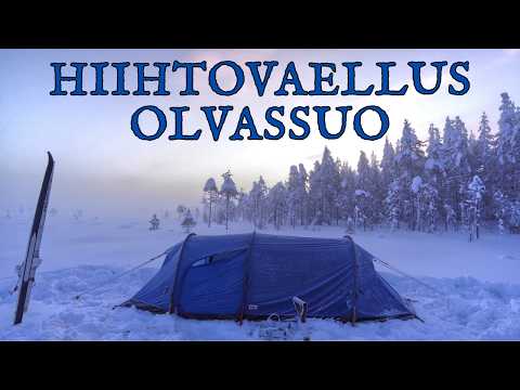 Tannejarvainen's film follows a winter ski traverse in the Olvassuo nature reserve and its title notes the demanding deep-snow conditions. It shows a more remote bog environment than the Rokua trail video. This is a specific winter outing, not a recommendation that every visitor attempt the same route.