Sysmä lies on the southern shore of Lake Päijänne, where water has long shaped routes, work and everyday life. Statistics Finland counted 3,367 residents in the whole municipality on 31 December 2025; this is not a population figure for the church village alone. Forest, farmland, islands and a deeply indented shoreline spread the community across a large rural territory. The village centre brings together the medieval church, daily services and the lake, while Päijätsalo and Kammiovuori offer very different ways to explore the surrounding nature.
Old routes and careful history
The municipal history account describes lakes and waterways as prehistoric corridors. Ceramic finds suggest permanent settlement from the early Comb Ceramic period, around 5100 BC, but the municipality stresses that Sysmä’s Stone Age has been poorly studied. About 130 prehistoric sites are known, many from the Viking Age and the period Finnish archaeology calls the Crusade period. A cairn at Suurikylä Ihananiemi is dated to the fourth century AD and one at Supittu to the seventh. The evidence gives the area a deep human history, but it does not justify turning every local story into fact. Sysmä has no confirmed ancient hillforts, according to the municipality. Linnavuori, by the mouth of the Tainionvirta, is a suggestive name and location, not proof that a fort stood there.
Later commerce also followed the water. Traders travelled upstream on the Tainionvirta; hunters brought furs and tar downstream to the Sysmä market. The river later powered mills and formed part of forestry transport. Today the same connected waters support boating, paddling and lakeside walks. Sysmä’s identity is therefore less about a single monument than the relationship between a village, its waterways and the dispersed settlements around it.
A medieval church and summer culture
St Olof’s Church, built between 1510 and 1520, is the principal landmark. Its position by Majutvesi reflects the practical value of water access as well as the setting’s visual character. The surroundings are a nationally valued cultural landscape; the old parish granary, built in 1855, and the former vicarage are part of the historic village environment. The church remains in parish use, so opening and access depend on the calendar.
Sysmä Suvisoitto, founded in 1986, brings concerts to churches, manor houses and other local venues after Midsummer. Its programme changes each year and gives visitors a reason to explore beyond the centre. The municipality’s visitor guide and digital guide list services across the area. That matters in a rural community where food, accommodation, shops and harbours are spread between villages and may operate seasonally.
Trails and a closed lookout
Päijätsalo, roughly seven kilometres west of the village, has marked trails in the landscape of Päijänne National Park. The municipal guide describes a trailhead by the parking area and a campfire place and dry toilet at Pyydysniemi; arrival is possible by road or boat. The trails remain open, but the lookout tower is closed because of rot. Metsähallitus said on 26 June 2026 that a repair date was unknown. Check current notices and do not plan a tower visit. There is no waste collection, so take rubbish away.
Kammiovuori, farther north, reaches 221 metres, the highest point in Eastern Häme. Its marked 3.1-kilometre route is moderate, with steep and uneven ground. Hiskia’s Cave is linked by oral tradition to an early twentieth-century hermit, not to a verified archaeological finding. The large glacial erratic Linta is another landmark. There is no water, toilet or winter maintenance on the route; bring suitable footwear and supplies and check conditions.
Arriving and planning
Municipal information places Sysmä about 70 kilometres from Lahti, a 30-minute drive from Heinola and around 100 kilometres from Jyväskylä. Buses connect to Lahti via Vääksy and to Heinola; rail connections require transfer at a larger hub. A pre-booked call taxi can connect Sysmä with Hartola and Highway 4, but runs are limited. Visiting boaters can use municipal harbour information. Check current timetables, reservation requirements, church and concert access, and trail conditions. A first visit can pair the church landscape with a lakeside walk; a longer stay can add either Päijätsalo or Kammiovuori, allowing time for the distances between sites.
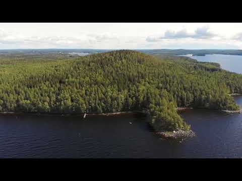 Three Sysmä videos: local introduction, Päijätsalo hike and Tainionvirta wildlife
 The title identifies an overnight hike to Päijätsalo, a nature area west of the village with marked trails and access to the Päijänne landscape. It offers a focused complement to Sysmä’s church and village history, especially for visitors considering time outdoors. The clip is not a substitute for current trail advice: check route conditions, facilities, access and the latest notice that the lookout tower remains closed.
 WWF Suomi’s live nature camera is explicitly located at the Tainionvirta in Sysmä’s Virtaankoski, as confirmed by the municipal notice of 6 October 2026. The river is also part of the area’s documented history of travel, trade and water-powered work. A live camera can change or be unavailable, so treat it as a remote window on local waters rather than a guaranteed wildlife sighting or a replacement for visiting guidance.