
A small centre with two different origins
Skurup feels like a practical southern-Swedish town rather than a preserved stage set. A railway station, a modest commercial centre and everyday services give it a working rhythm; a few streets away, a medieval church and fragments of an older farming settlement tell a much longer story. A green hill rises near the built-up edge, and the castle park at Svaneholm makes an easy excursion. The town is a useful base for reaching both inland villages and the coast around Abbekås.
Statistics Sweden (SCB) counted 9,233 people in Skurup’s statistical locality, or tätort, for the reference date 31 December 2023. This is the population inside SCB’s defined contiguous built-up area, not the larger municipality, which includes other settlements and countryside. The distinction matters: Skurup is the municipal centre, but the name also refers to a much wider rural district.
Church village, then station settlement
The municipality’s local-history account begins with Skurup as a church village. The parish church, usually called Skurup Church or Mariakyrkan, stands in that older setting. Municipal material places the late-eighteenth-century enclosure reform, enskifte, at the centre of local change: in the 1780s farms and village commons were reorganised, and a five-way meeting point known as Femkorset became a hub in the road pattern joining four villages. That geometry can still be read in the landscape, although the roads belong to a living town, not a complete open-air museum.
The church is the clearest surviving witness. The parish history dates its original construction to around 1200 and describes a Romanesque basilica with nave, narrower chancel and rounded apse, built of grey stone and limestone. In the fifteenth century, brick vaults replaced the earlier flat timber ceiling. Later additions altered its outline, yet the interior carries medieval layers: wall paintings, carved and painted fittings, memorial stones and the crypt begun in 1590. A sixteenth-century church seal shows the crowned Virgin Mary, evidence behind the name Mariakyrkan. The parish account is careful about what is known and what remains uncertain, including who commissioned the first church.
Skurup’s second centre took shape with the railway. The Malmö–Ystad line opened in 1874, and the municipality says commerce and new building gravitated toward the station. This newer settlement was once called “stationen”; brick buildings along Kyrkogatan preserve some of the railway-era ambition. The two centres are close enough for a walk, but their different roles remain legible: the church village looks back to parish and farm life, while the station area connects residents to work, education and regional travel.
Everyday services and a hilltop view
Today’s economy is best understood at two scales. Skurup serves as a municipal centre, with shops, food businesses and public services around the core, while a separate commercial area has drawn some larger retail activity away from the older high street. The municipality’s own centre analysis documents that shift rather than presenting the town as a single shopping strip. In the wider municipality, small firms and rural activity matter, but municipal-wide figures should not be mistaken for employment counts within the tätort. The result is a place where the station and centre remain useful even if visitors arrive mainly for history, landscape or a coastal day trip.
Zimmermans backe is the simplest outing from town. The municipality describes it as a small nature reserve at Skurup’s northern edge, roughly 25 metres above the surrounding settlement. A bench and table offer a pause; on clear days the elevation opens a broad view across the lowland. In winter the slope becomes a local sledging hill. Municipal storytelling links the name to nineteenth-century farmer C.F. Zimmerman and a maple planted on the summit. Treat that picturesque origin story as local tradition, not established fact; the hill, tree and outlook are the reliable attractions.
For a longer walk, continue to Svaneholm Castle, a short trip beyond the centre. The municipality lists two marked paths of 2.6 and 4.2 kilometres around the estate, with a park, lakeside, picnic places and wind shelters. The routes make a visit worthwhile even when the castle rooms are closed, but museum and restaurant access follows its own calendar. A municipal cycle plan documents links toward the castle; check the current map and conditions rather than assuming every segment is traffic-free.
Getting around and seeing more
Skurup station is served by Pågatåg on the regional railway, with connections toward Malmö and Lund in one direction and Ystad and Simrishamn in the other. The municipality and Skånetrafiken also list local buses: route 305 heads toward Abbekås, 306 runs via Slimminge and Svaneholm, and 307 links toward Ystad. Some trips are demand-responsive and require advance booking, so a route number alone does not guarantee a departure. Check the current journey planner, especially for evening and weekend travel.
A rewarding first walk follows the centre’s streets between the station, Stora Torggatan, Kyrkogatan and the church village, pausing where the brick station-era town gives way to the older parish core. Then climb Zimmermans backe for a view, or take a local bus toward Svaneholm and use one of the marked estate trails. The town’s scale makes a half-day easy; connecting it to the castle or the coast turns the visit into a fuller Skåne outing. Opening times, buses, museum access and seasonal facilities can change, so confirm practical details before setting out.
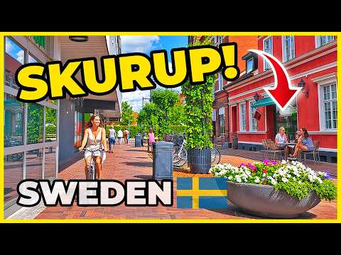 Three verified glimpses of Skurup, its hill and Svaneholm
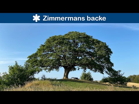 Mikey WooDoo’s “Zimmermans backe - Skånes naturreservat” dates from 17 August 2020 and runs 3:33. Its description calls the reserve small, about two hectares, and mentions its roughly 25-metre hill. It is a concise introduction to the green rise at Skurup’s edge, not a substitute for current local access information.
 Sven Rosborn’s “Svaneholm slott och museum” was published on 20 March 2014 and runs 3:22. Its description identifies Svaneholm castle and museum as a notable part of Skåne’s cultural heritage. Because it is an older clip, use it for historical atmosphere rather than present-day opening arrangements.