Savitaipale is a small South Karelian municipality built around a meeting of water and ice-shaped land. Statistics Finland counted 3,094 residents in the municipality on 31 December 2025. The central village stands on the shore of Lake Kuolimo, where the inner Salpausselkä ridge rises above the water; the municipality says the ridge's northern edge reaches roughly 40 metres in places. This setting helps explain why the area feels more like a network of lake villages than a single destination: the centre, its museum hill and the old military sites at Partakoski are linked by roads but each has its own landscape.
A name shaped by a route across land
The municipality dates Stone Age dwelling places around Kuolimo to 3000–1600 BCE and notes that village names appear in a tax record from 1540. Savitaipale became an independent parish in 1639, after people in the Peltoinlahti prayer district petitioned to form one. The place-name is commonly explained as a reference to the clay shore at Savilahti and a taipale, a portage between waterways. The municipal history presents this as the likeliest explanation, not a settled fact. The image is fitting nonetheless: for centuries, this was a landscape where movement between lakes mattered.
The centre remains close to the water and to the long ridge left by glacial meltwater. Saimaa Geopark interprets the surroundings through kettle terrain, eskers and local rapakivi granite. The municipality's red-granite church, designed by Josef Stenbäck and completed in 1924, uses that regional stone in a prominent village landmark. Nearby, the separate bell tower houses an exhibition on local church builders Juhana and Matti Salonen and Taavetti Rahikainen, known for their double-cross churches. It is a small but revealing detail: Savitaipale's history is not only about the buildings that survived, but about craftsmen who carried their methods across the region.
Hakamäki: local memory above Kuolimo
Hakamäki is the most natural place to slow down between the village and the lake. The open-air museum gathers folk buildings, tools and textiles around a main dwelling, granary, windmill, soldier's cottage, smoke sauna and threshing structures. A 14-metre lookout tower, built in 2008 in the spirit of an earlier tower, opens a view over Kuolimo. The wooded slope is a protected natural area, and its stage hosts summer music and theatre. The museum's regular season is short, generally mid-June to the first weekend of August, so check the current opening calendar before planning a visit.
Summer visitors often arrive for the lake as much as for heritage. Municipal visitor information lists hiking, fishing, paddling, cycling and cottage stays among the area's common activities; in winter, residents skate on the lake when conditions permit. The municipality also describes year-round music and a July festival week, with the church and Hakamäki serving as event venues. Shops, basic public services, schools and health services are concentrated in the village centre, while food, accommodation and outdoor options are spread among settlements and lakeshores. A seasonal café or event should never be assumed open without checking.
Partakoski and a fortress on the old frontier
About nine kilometres from the centre, Partakoski occupies a narrow neck between Kuolimo and Saimaa. A marina and a distinctive stone arch bridge mark the village; the rapids themselves connect the two water systems. Beside them, Kärnäkoski fortress looks back to a period when this was a strategic frontier. The Finnish Heritage Agency dates its construction to 1791, under the direction of General Aleksandr Suvorov, as part of Russia's defence system protecting St Petersburg. The fortress was decommissioned in 1809, when the border moved. Its earthworks, stone-faced walls and foundations survive in a landscape that now invites walking rather than military use. Stay on the marked paths and do not disturb the protected remains.
The wider area has a quieter appeal too: short forest paths, water views, boat access and the shifting light over the eskers. A municipal leisure-cycling loop around the village is 20 kilometres, while a separate mountain-bike route is 28 kilometres and follows a different level of effort. The regional Saimaa archipelago route links Savitaipale with other South Karelia villages and ferry crossings, but its boats run seasonally. Check current ferry dates and ticket arrangements before building a day around an island connection.
Getting there from Lappeenranta
Savitaipale sits on Highway 13, 37 kilometres from Lappeenranta, according to the municipality; Mikkeli is about 70 kilometres away and Kouvola about 80. Lappeenranta is the nearest city with a railway station and airport. Public movement within the municipality includes demand-responsive taxi routes, but these are booked in advance, run on specific weekdays and can change with school transport. They are not a substitute for checking a visitor's exact connection. A car or bicycle is useful for reaching Partakoski and the fortress, while the village centre itself is more compact. Check bus, booking and ferry information for the travel date, and allow time to experience the lakeside rather than treating it as a quick stop.
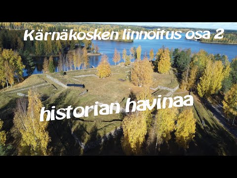 Savitaipale on film: a fortress, Partakoski and the village church
 The second film moves from the fortress to Partakoski, the nearby village and rapids. Its subject is the waterway and the local landscape, a useful counterpoint to the first video's military remains. The municipality places Partakoski about nine kilometres from the village centre and notes its marina and stone arch bridge. The video is an independent scenic portrait; check present services, water conditions and access before travelling.
 An aerial view of Savitaipale church gives a sense of how the village landmark sits within the centre beside Kuolimo. The image is useful for orientation and for seeing the roofline and setting from above, but it does not explain the church's construction or say when visitors can enter. Pair the footage with the church's documented story and confirm opening arrangements with the parish before planning an interior visit.