A coast made of villages, not one resort centre
Korsnäs is a small municipality on Finland’s Ostrobothnian coast, where the Gulf of Bothnia meets a long, rocky shoreline. It is often described as the westernmost mainland municipality in Finland. Rather than a single compact tourist centre, it is a network of villages—among them the church village, Molpe, Harrström and Taklax—set between forest, marsh, fields and skerries. Statistics Finland counted 1,984 residents in the whole municipality on 31 December 2025. The municipality reports that Swedish was the mother tongue of 84% of residents at the start of 2024, which is why this guide’s local edition is in Swedish.
What the records say about its past
The first surviving written mention of the district dates to 1442; that is not a founding year. Local self-government began in 1868, and Korsnäs became officially independent from Närpes in 1887. The present municipal map changed again in 1973, when Töjby and Träskböle were transferred to Närpes. This layered history is better read through village places than through a grand origin story: a church whose predecessors reach back to the medieval period, fishing settlements and farms, and, in the 20th century, a mine that briefly altered work and landscape.
The lead deposit was discovered in 1955, and the headframe that still marks the site was built in 1958. Mining began in 1961, stopped for a period in 1963, resumed and ended in 1972; the processing plant continued with ore from Petalax into 1973. The municipality’s mine exhibition explains that industrial chapter at announced visiting times. The 45-metre tower is not open for climbing, and visitors should follow current access restrictions around the former mine rather than treating the surrounding waste area as a walking route.
Craft, church and the villages’ landmarks
Korsnäs is especially associated with its bright, intricate sweater, which combines knitted and crocheted sections. The local heritage museum displays examples in a textile room opened in its present form in 2000; the heritage association identifies the oldest sweater in its collection as dating from 1864. That tradition connects the visitor to skilled work by local women and to a material culture that is still demonstrated, not merely kept behind glass.
In the church village, the current wooden church was designed by C. L. Engel and built in the 1830s. Its predecessor story reaches further back, but the surviving building belongs to the 19th century. The old farm cottage that houses the heritage museum and the nearby rectory museum provide a more intimate view of household life. In Harrström, two windmills stand on Kvarnbacken: the larger, built in the 1840s, remains on its original site. The village’s old fishing harbour, a fisherman’s cottage interpreting life around 1900, and a stone bridge built in 1898 reward a slow visit.
From the swimming beach to the outer islands
Molpe offers one of the municipality’s easy coastal stops: a public bathing beach with a restaurant beside it, plus guest harbours and summer activities. Farther offshore, Molpehällorna is reached by boat through a marked channel. The former coastguard station now serves as a nature station, and a marked trail of about one kilometre crosses a mosaic of young woodland, reed beds, bays and rocky shore. The municipality places the island about six kilometres by water from Bredskär fishing harbour and eight from Strand-Mölle. Arrange a boat or charter in advance; there is no road connection, and weather and seasonal access matter.
For walking on the mainland, the municipal listings include the roughly 7.3-kilometre Waterloo trail and the 3.6-kilometre Hinjärv trail. Hinjärv is a shallow, humic lake set among the forests and wetlands of Taklax. These are modest landscapes best appreciated at walking pace: open water, spruce and birch, old fishing places and villages where the distances between stops make a car or bicycle useful.
Getting there and planning a stay
Vaasa is the nearest place for rail, airport and port connections. By road, regional road 673 runs through Korsnäs; from Vaasa, follow the coastal route south via Malax, then use local roads for Molpe, Harrström or Taklax. A published route 360B also runs from Vaasa through Malax, Övermalax and Petalax to Korsnäs on selected weekdays during school-holiday periods, but the service is limited. Check the operator or journey planner for the exact travel date before relying on it. Vaasa and the neighbouring municipalities of Malax and Närpes make natural extensions to a coastal itinerary. In Korsnäs itself, the library, bathing places, restaurant, guest harbours, museums and seasonal guides provide useful visitor services; confirm opening times and book boat transport before setting out.
 Korsnäs in three videos: its sweater, the outer archipelago and offshore wind
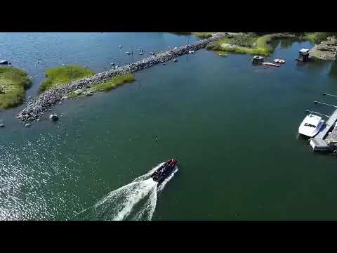 VisitVaasa’s short clip shows a West Coast Rib Charter boat arriving at Molpehällorna. It gives a brief visual sense of the boat access needed for this outer-archipelago stop, where a former coastguard station now serves as a nature station. It is a short arrival shot rather than a route guide; check the municipality’s visitor information and arrange a current boat service before travelling.
 Metsähallitus presents the Korsnäs offshore wind farm project in this 2026 video. The proposal concerns a site about 15 kilometres off the coast and remains a project in development, not an operating attraction or completed wind farm. The video helps explain a possible future economic and energy chapter for the municipality; the project page should be consulted for current planning status.