Allerona rewards a visit that moves between three different settings: a compact hilltop settlement, a broad rural municipality and the wooded estate of Selva di Meana. Its surviving streets and gates are not a staged tableau; they sit beside an everyday community whose calendar still includes a May procession, whose countryside is shaped by farming, and whose visitor facilities are small enough that checking ahead matters. The landscape crosses the borderlands of Umbria, Tuscany and Lazio, while the centre looks toward a much older route between Rome and Chiusi.
Istat’s resident-population estimate for 1 January 2026 puts the whole municipality at 1,679 people. It is an estimate based on census results and the provisional 2025 population balance, not a final count, and it describes the comune rather than only the historic centre. The municipal history suggests that “Allerona” may derive from Lerona or Vallerona, a local word associated with the strawberry tree. It also says that an ancient vicus of Lerona existed in Roman or pre-Roman times, while presenting Etruscan settlement as probable. Those are claims in the town’s historical account, not proof that the present village was founded by Etruscans or Romans. Traces of Roman paving and two milestones are associated with the old Cassia or Traiana Nova road in the area.
A castle village with a layered record
The medieval settlement grew around the castle of Lerona, of which parts of the walls and the two approach gates survive. The eastern entrance is called Porta del Sole; Porta della Luna faces west. The names give the walk a memorable structure, but the town’s exact castle chronology should be treated carefully: the municipal history places the new castle shortly before the year 1000, whereas the regional tourism account associates the castle with the twelfth century and records a building episode in 1275. Rather than flatten those accounts into one invented date, the secure visitor’s picture is a medieval fortification whose remains still shape the upper village. The regional account places its destruction in the late fifteenth century; the municipal narrative’s identification of the French king is chronologically inconsistent, so it is safer not to repeat that attribution.
At the high Piazza Santa Maria, the former castle area brings together several periods. Santa Maria della Stella has a twelfth-century foundation and was redesigned by Orvieto architect Paolo Zampi in 1892–97. Nearby Palazzo Visconteo began as a fourteenth-century building connected with the Monaldeschi and became a noble residence in the fifteenth century. Santa Maria Assunta, the parish church within the village, is a separate building whose documented form belongs to the fifteenth century. A short walk beyond the centre reaches the octagonal Madonna dell’Acqua sanctuary, built in the early eighteenth century over an earlier votive chapel beside a spring. The water was regarded as miraculous: that is a local belief, not a claim that can be verified as an event.
The Pugnaloni: a tradition that has changed
Allerona’s most distinctive public celebration is the Festa dei Pugnaloni, held on the second Sunday of May in honour of Saint Isidore, patron of farmers. Today’s Pugnaloni are allegorical carts with a decorated poplar tree and scenes of rural work; the figures, animals and tools are made by local residents from wood and clay. The municipal account says this form took shape after the Second World War. It also preserves descriptions of an older pre-war custom that looked quite different, a reminder that tradition is made and remade rather than passed down unchanged. Stories linking the feast to pagan offerings to Ceres or Mercury are explicitly presented as theories. The procession and its place in Allerona’s calendar are documented; an unbroken ancient origin is not.
The celebration makes most sense as part of a working countryside. A municipal planning document identifies viticulture, olive growing, vegetables and cereals among the area’s agricultural production, with pastoral activity nearer the uplands. This is not a claim that every farm is open to visitors, but it explains why Saint Isidore and the imagery of ploughs, animals and harvest remain so legible here. The weekly market in the main village moved to Mondays from 28 September 2026, according to a municipal notice. Restaurants, local shops and accommodation are listed by the Comune, but small-town opening patterns vary; check individual businesses before relying on a meal or overnight stay.
Gardens, woodland and a small museum
In the wider municipal territory, Villa Cahen offers a striking contrast with the medieval centre. Antwerp-born financier Edouard Cahen built the villa in 1880 in the Selva di Meana estate. The gardens combine designed spaces with mature trees and plant collections; their restoration was completed with a public reopening in April 2025. The villa’s published garden hours are 9:00–13:00 on weekdays throughout the year, with weekend opening from May through September. Confirm the current arrangement before travelling, especially if you hope to join a guided visit. The nearby Parco di Villalba is a separate wooded, equipped park of more than 20 hectares, described by the regional tourism service at an elevation of 600–700 metres.
There is also a more unexpected way to read the surrounding landscape: the Museo dei Cicli Geologici del Golfo dei Cetacei presents fossil evidence of ancient marine environments, including molluscs, sharks, cetaceans and fossil amber. The Comune’s visitor office can advise on opening times for this museum, the Museum of the Pugnaloni, sacred-art collections and guided visits to Villa Cahen. It is in Piazza Attilio Lupi; the municipal portal lists +39 379 321 0775. As these visits may depend on arrangements rather than continuous opening, call or write ahead. A sensible day can pair a slow walk through the gates and churches with one confirmed museum or garden visit, rather than trying to fit every site into a fixed timetable.
How to reach Allerona and plan a stay
By road, the Comune recommends the Orvieto exit from the A1 motorway. For public transport, Orvieto is the practical rail gateway: Busitalia’s winter 2026–27 timetable lists line E648 from Orvieto railway station through Allerona Scalo to the hilltop terminus, with a reverse service. Departures are marked by weekday, school-day and non-school-day codes, and the number of useful connections is limited. Check the current timetable for the exact date, and allow for the separate transfer between Orvieto’s station and old town if you plan to visit both. Line E646 also links Orvieto, Allerona Scalo and Fabro, but it does not replace the E648 stop at the hilltop centre.
Allerona is best approached as a place to notice transitions: Roman road traces beneath a medieval story, a village festival that has adapted across generations, and a garden estate set within woodland. Its modest scale is part of the visit, not a promise of big-city services. Ask locally about guided walks and openings, leave time for the steep lanes, and check transport and seasonal hours before setting out.
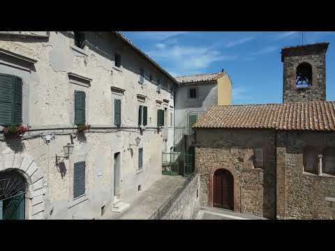 Allerona in tre sguardi: vicoli, passeggiata e paesaggio umbro
 This independent 4K walking tour stays near street level and gives a more gradual sense of moving through Allerona than an aerial montage can. Its strongest value is visual orientation: viewers can notice the close sequence of lanes and façades and decide whether the hilly centre suits the kind of walk they want. The subtitles and broad historical framing make it accessible to viewers who do not know the area, but it is not a survey of every monument and it does not replace a guide. The recording dates from 2021, so current access and opening times need separate checking.
 Italia.it’s short Borghi Viaggio Italiano feature places Allerona within a broader tourism portrait of Umbria, pairing the village name with the region’s landscape, outdoor routes, culture and food themes. It works as an invitation to explore and as a quick visual contrast with the longer town walk. The treatment is promotional and necessarily brief: it should not be read as a detailed itinerary, a current service directory or evidence for a specific historical claim. Published in 2022, it is best watched alongside current municipal information when planning a visit.