Usseaux is best understood as a small constellation rather than a single village. In the upper Val Chisone, near the French border, its five borgate—Usseaux, Balboutet, Pourrieres, Fraisse and Laux—are strung along a steep Alpine landscape. The municipal territory covers 38.32 square kilometres and ranges from about 1,210 metres in the valley to peaks approaching 2,890 metres. ISTAT records 174 people in the row “population censused at 31 December” for 2024, for the whole comune (code 001281), not for the main hamlet alone. The official count helps explain the scale of the place: a living, spread-out mountain community with long distances between its homes and high pastures.
The centre at Usseaux is known for painted scenes on house walls, but the murals are only one layer of its character. Stone-and-wood houses, fountains, narrow lanes and a large washhouse recall a settlement shaped by water, farming and winter. The Comune describes Alpine Occitan patouà as a language still spoken in the valley, alongside Italian, and identifies the area with Occitan cultural history. Balboutet gathers its own identity around sundials and Piazza del Sole; Laux sits beside a small lake under the rocky Rocca of the same name; Pourrieres is associated with the Assietta highlands and the 1747 battle; Fraisse is the wooded hamlet. These are not interchangeable stops: the distances are short on a map, but each has a distinct setting and story.
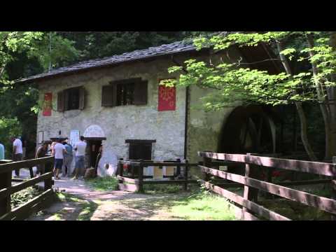
Work and visitor life remain tied to the mountain environment. Municipal listings show farms and agriturismi in Balboutet, restaurants and other small hospitality businesses across the villages, and a tourist information point in Usseaux. Pasture land, local food and small-scale rural activity sit beside walking and winter recreation. The old Canton watermill offers another tangible link to the grain economy. The municipality’s account says the mill belonged to the Canton family for generations; a 1930 avalanche damaged it, it was rebuilt after the war, and milling later ceased as local grain production dwindled. It was restored and returned to occasional demonstration use, but public openings are seasonal rather than guaranteed. Local events include agricultural, food and cultural gatherings; check the current calendar instead of relying on a past festival date.
The written record offers a firmer anchor than origin stories. The Comune dates the first documentary notices for Usseaux, Pourrieres, Balboutet and Fraisse to 1064, in connection with Countess Adelaide’s endowment to the Abbey of Santa Maria in Pinerolo. It places the hamlets within the historical Escartons network, whose communities had a measure of local self-government from 1343 until the transfer of the eastern Alpine valleys to the House of Savoy in 1713. The Assietta ridge above Pourrieres then became the scene of a major Franco-Savoyard battle in 1747. Usseaux’s own page also suggests a Celtic origin for the name and a possible link to Caesar’s “Occellum”; those identifications are hypotheses, not settled proof of the village’s ancient name.
Laux has a separate story, but it should be told with the same care. The municipal history attributes its settlement around 1200 to religious exiles from Lyon and Provence, later joined by Waldensian “Poor of Lyon”; it is an attributed local account, not a fully documented founding charter. More securely visible today are its chapel, pedestrian lanes, fountains, small lake and the dramatic rock wall above it. The parish church of San Pietro in Usseaux stands at the edge of the old centre; the Comune records a church here in 1098 but says the site of that earlier building is unknown. The present church is described as a later structure, with a high position and a view down the Chisone valley. Municipal listings also identify chapels at Fraisse, Pourrieres and Laux.
For a walk that connects village life with the open slopes, the municipal route “Verso i pascoli di montagna d’Usseaux” provides a downloadable GPX. It starts in Usseaux at about 1,405 metres and reaches Casa Pascalin at 1,706 metres: approximately 3.5 kilometres each way with about 350 metres of ascent. The official access notes place parking along Via al Lago and a bus stop on SP23r about 0.9 kilometres and 50 metres of climb from the trail start. The municipality lists 13 walking itineraries, including routes to the Laux and the Assietta. Mountain weather, snow, trail markings and road access change with season; use the current GPX and check conditions before leaving. The higher extension above Rocca del Laux is explicitly described by the Comune as exposed and poorly marked, suitable only for experienced hikers.
Usseaux lies about 40 kilometres from Pinerolo, 20 from Sestriere and 80 from Turin, according to the municipal territory page; Briançon is across the border at roughly 50 kilometres. The usual valley approach follows the route from Pinerolo toward Sestriere and the SP23 corridor. A staffed tourist information office is listed at Via Conte Eugenio Brunetta 53, with WhatsApp and email contacts, while food and lodging hours vary by establishment. Streets are steep and stone-paved; winter footwear and time for the hamlets are sensible. Confirm bus times, restaurant service, mill demonstrations, church access, events and trail conditions shortly before a visit.
 Usseaux in three views: murals, five hamlets and an Alpine walk
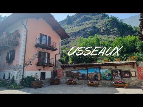 Paolo Lo Cascio’s 3:35 introduction, posted 26 June 2023, offers a quick overview of the five hamlets and their separate calling cards, including Usseaux’s murals and Balboutet’s sundials. Its concise format makes it a useful orientation before exploring the municipal maps, while its description supplies more detail than the short runtime can itself establish. It is a creator’s travel feature rather than an official service notice; confirm transport, access and opening information with the municipality.
 Voyatours published this 53:13 walking-tour video on 3 March 2024. The title and description identify it as a long-form walk through Usseaux, giving it a different role from the two short explanatory features: it is an atmosphere-and-route preview, not a substitute for a current GPX or trail report. The channel metadata and player status were checked; conditions, access and services on the ground can change after filming.