A village above the Tanaro plain
Guarene is one of the hill towns of the Roero, in the province of Cuneo, a short distance from Alba. Its old centre climbs toward a castle that is visible from across the surrounding countryside. The municipal site records 3,532 residents in the entire comune on 1 January 2025, over 13.68 square kilometres; this is the population of the administrative municipality, not just the historic centre. Nine named hamlets and localities extend beyond the hilltop, including the agricultural plain of Vaccheria. The setting gives Guarene two distinct visitor experiences: a compact, steep historic core and a more dispersed territory of orchards, vines, small settlements and views across the Tanaro valley.
The first settlement, according to the municipality, lay on the plain below the present village. Residents later moved toward the castle hill in search of a safer, more defensible position. The castle began as a military and territorial-control structure, then changed into a noble residence as political conditions shifted. That movement from plain to hill is still legible in the way the settlement gathers below the castle rather than spreading evenly across the slopes.
A careful account of medieval power
Guarene’s own historical summary cautions that reliable documents are lacking for parts of its early jurisdiction. After disputes between the communes of Asti and Alba, the village became a possession of the bishop of Alba. The later transfer to the Roero family is also not settled by a single account. One version says that the military captain Vagnone Vittor of Trofarello took Guarene back from foreign troops on the bishop’s behalf and claimed the fief as compensation; another says the bishop granted it to him in 1348. The records cited by the municipality then place the Roero purchase in 1379. The uncertainty belongs in the story: it is not a blank to fill with a more dramatic invention.
Relations between the Roero lords and the townspeople were tense. In 1530 a dispute with Countess Caterina Roero led residents to sack the castle twice; in 1564 they attempted to kill Count Teodoro II. The balance changed over generations, but war, food shortages and plague left a harder mark. The local account says the 1631 epidemic halved Guarene’s population. The village’s religious buildings preserve another part of that chronology: after the outbreak, residents built San Rocco as a vow of gratitude for surviving the calamity, and the chapel remains associated with the saint’s August 16 observance.
The castle is a landmark, not a walk-in museum
The present Castello di Guarene took shape in the eighteenth century. Work began in 1726, when Carlo Giacinto Roero almost entirely replaced the older fortified building with a residence; the complex was completed around 1775. Local tourism history notes that Filippo Juvarra’s influence was long assumed because of his friendship with the count, but attributes the project to Carlo Giacinto himself. The Italianate gardens occupy two terraces south of the building. The castle passed to the Provana di Collegno family after the Roero line ended in 1899, then to new owners in 2011.
Today the property combines hospitality, a restaurant and museum rooms. Its official site states that museum visits are available by reservation; a visitor should not assume that the gates or interiors are open for casual entry. Even from the public streets and viewpoints, however, the castle defines the village’s skyline and helps explain the close relationship between Roero feudal power and the architecture below it.
Churches, public art and a walk through the centre
Guarene’s cultural route is unusually practical: the municipal Architinera project links eleven points and provides a tactile map and audio material for exploring the town. Its stops include Piazza Roma, the churches of San Rocco, San Michele, the Santissima Annunziata and Santi Pietro e Bartolomeo, the castle buildings, the Poggiolo and the sferisterio. These are not interchangeable interiors. San Michele, documented in 1379 and described as the oldest church in the village, is deconsecrated and currently unused; the municipality says cultural uses are under study. The Annunziata is a restored example of Piedmontese Baroque decoration and can host exhibitions, concerts and other events. Access to both should be checked against current notices.
At the Collina di San Licerio, the tourism site describes a permanent open-air art park established with the Fondazione Sandretto Re Rebaudengo, including Paul Kneale’s 2019 installation Flat Earth Visa. This walk connects landscape and contemporary art without requiring the visitor to enter a private palace. In Piazza della Pantalera, a mural celebrates the local tradition of pallapugno, a ball game played against a wall. Together these stops show how Guarene’s identity is not only aristocratic: public art, community sport and small civic spaces also shape the place.
Vines, orchards and a pear with a local origin
Agriculture remains part of the way Guarene is read and tasted. The municipal visitor guide describes vines and fruit trees on the hills, hazelnut groves across the territory, and vegetable cultivation in the lower Vaccheria area, including tomatoes, peppers, garlic and cardoons used in regional cooking. The Madernassa pear gives the town a particularly specific food story. According to the local account, the variety began around 1784 at Cascina Gavello in the Madernassa hamlet, then within Guarene; it was first called Gavello before taking the name of the locality. It is well suited to cooking, and the local guide notes its use in pear tarts and in pears cooked in wine. This is a documented cultivar story rather than a claim that one fruit defines every household or business.
The wider Roero landscape adds the contrast of vineyard slopes, fruit-growing land and the erosional ravines known as the rocche in other parts of the territory. Near Guarene, the view is more directly tied to the Tanaro and the cultivated hills. A clear day can make the visual connection between Alba, the villages across the valley and the agricultural pattern especially easy to understand.
Getting there and making the day work
Guarene’s tourist information places Alba about 10 kilometres away. Visitors arriving by rail can use Alba, Bra or Asti stations; the municipality lists a Turin–Alba coach and a local Alba–Guarene bus, while GTT’s current route information identifies the service through Alba, Mussotto and Guarene. Check the day’s timetable and the precise stop before travelling. By car, the official directions point to the A33 Castagnito exit; other approaches use the A6 at Marene or A21 at Asti Est before continuing toward Alba. Road works and traffic can change the easiest route.
For a first visit, follow Architinera from the historic centre, reserve a castle museum visit in advance if that is part of the plan, and leave time for the view from the public hilltop and the San Licerio art park. Food shops, restaurants and local producers are spread across the municipality, so confirm opening days before planning a meal around one business. Guarene works best as more than a quick photo stop: the castle explains the hill, the churches and civic route make the old centre walkable as a sequence, and the Madernassa pear and working fields connect the village to its present-day landscape.
LINKS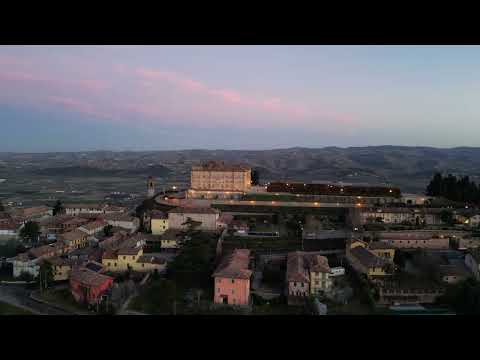 Guarene on film: the hilltop, its Baroque castle and a Roero pear
 This interview features Daniele Occhetto, identified in the title as president of the Pera Madernassa Consortium. It adds a producer’s perspective to the fruit’s connection with Guarene and the Roero, complementing a walk among the village’s agricultural landscape.
 This longer travel portrait presents Guarene as an old village in the Roero. Its broad town focus makes it a useful companion to the more specific castle-at-sunset and pear-producer films; viewers should still check current visitor information before planning access.