Sulkava is a small South Savo municipality whose scale is measured as much in water routes and summer gathering places as in its quiet church village. Statistics Finland counted 2,310 residents across the municipality on 31 December 2025. The settlement story has a documented starting point: the municipality dates its foundation to 1630. Today it sits among the islands and inlets of Lake Saimaa, with local life shaped by forest, agriculture, boat traffic and a strong calendar of community events.
A village set between the church and Saimaa
The centre is compact enough to explore on foot, and its lakeside streets preserve a distinctive wooden-townscape. Visit Sulkava describes the area between the Saimaa shore and Mikkolantie as a nationally significant visitor attraction, with mansard-roofed houses and traditional yards. This is not a reconstructed old town: it remains part of the lived-in centre, where shops, food, accommodation and everyday services sit close to the waterfront. The shoreline also explains the village’s older geography. The municipality’s visitor history notes that many parishioners once reached church by water, so the lake was a route into the community as well as its setting.
The present church, a double-cross-plan building, was completed in 1822 using plans by state architect Charles Bassi. It replaced a smaller church as the parish grew. Its place beside the water makes sense in a municipality where boats once connected distant settlements. A short walk through the centre can pair the church with the old wooden streetscape; the nearby Rauhaniemi local-history museum offers a different way to read rural life, displaying buildings and objects associated with work and domestic routines. Museum access is seasonal, so check current opening information before making it the anchor of a trip.
Rowing is a local tradition, not just a summer spectacle
Sulkava’s best-known event is the Sulkavan Suursoudut, a rowing gathering held annually since 1968. It grew from a local competition into a multi-day summer event that brings together racing, recreational rowing and the social life of Saimaa. The event website describes a programme for both competitors and visitors; dates, registration and shore-side activities change from year to year. Even outside event week, rowing belongs to the area’s identity because the lake has long been the practical landscape of travel, work and leisure. For visitors, the race is a chance to see how waterways connect villages that appear scattered on a road map.
Partalansaari is a useful starting point for a slower exploration of that island geography. A local story map gathers place histories, natural features, sights and fire sites along routes around the island. Its stories were collected in a community project and should be read as recorded local memory where they are presented as tales, not as archaeological proof. On the mainland and island shores, the route through the municipality is less about ticking off a single landmark than choosing a sequence of short walks, viewpoints and village stops.
Hillfort, bridge and a road made for stopping
Pisamalahti hillfort stands out for its position above the water and its recognised archaeological importance. The Finnish Heritage Agency’s cultural-environment register identifies it as one of Finland’s best-known ancient hillfort sites. The visitor information describes the climb and approach, but it does not establish a precise construction date; the article therefore leaves the site’s chronology open rather than turning a striking name into a dramatic origin story. It rewards a visit for the relationship between the steep terrain, the lake channel and the wider Saimaa landscape.
Road 438 links the church village with Lohilahti and is promoted locally as a scenic route. Along it, the Vekaransalmi bridge crosses a water passage that once divided and connected communities; the municipality calls it Finland’s fifth-longest bridge. The bridge’s viewing platforms offer a natural pause, while Lohilahti and the villages along the road provide reasons to continue rather than turn back immediately. The same route brings visitors near the Rauhaniemi museum area and other shoreline places. Conditions, services and opening times vary, so check the local map before setting out.
Getting there and making a practical visit
Visit Sulkava lists Savonlinna 38 kilometres away and Mikkeli 78 kilometres away by road. Savonlinna is the nearest airport and passenger rail station named in the local visitor guidance; the final leg can be made by bus, rental car or taxi, depending on the timetable. The municipality publishes bus corridors connecting Savonlinna, Sulkava and Puumala, as well as Mikkeli, Juva and Sulkava. These services do not operate like an urban network, so build the itinerary around a confirmed departure and verify the return connection before travelling. A car makes it easier to reach Partalansaari, Pisamalahti and the route toward Lohilahti.
For a first visit, allow time for the church village and its waterfront, then choose either the hillfort or a longer drive along road 438. A summer trip can add Rauhaniemi or the rowing event, but both depend on dates and current opening arrangements. Sulkava’s appeal lies in the combination: everyday wooden streets, a working lake landscape, community memory and a few powerful viewpoints rather than a dense circuit of ticketed attractions.
 Sulkava in three views: the village, Pisamalahti and Vekaransalmi
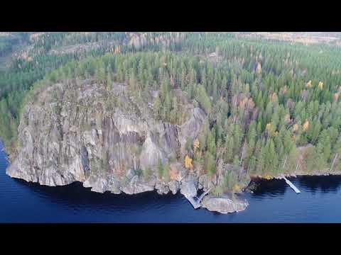 Lohilahti Shutterbug team’s video is identified by its title as Pisamalahti hillfort in Sulkava. The site is recognised in Finland’s cultural-environment register as a notable ancient hillfort, and the local visitor page explains the approach. The video offers a visual introduction to the landmark, while its exact archaeological chronology should be taken from heritage research rather than inferred from the footage or the name.
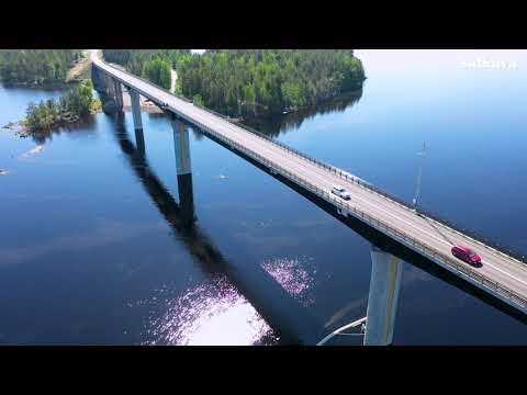 SulKanava’s scenic-road film is titled Vekaransalmi road 438. That makes it a useful companion to a drive between Sulkava’s church village and Lohilahti: the route includes a bridge over an old water passage and several places to pause by Saimaa. Use the clip to preview the corridor, then consult local maps for stops, current services and road conditions.