Sastamala is best approached as a small city spread across a broad rural landscape, not as one compact town. Statistics Finland counted 23,332 residents in the municipality on 31 December 2025. Its 1,531 square kilometres include 102 square kilometres of water, and the population is distributed among Vammala, Karkku, Mouhijärvi, Kiikoinen, Suodenniemi and other communities. The lakes and river channels are part of the townscape: they separate villages, frame old churches and make the central area feel more like a waterside meeting place than a conventional street grid.
A city assembled from older communities
The current city dates from 1 January 2009, when Vammala, Mouhijärvi and Äetsä joined. Suodenniemi had become part of Vammala in 2007, and the municipal history records an earlier 1973 merger that brought Karkku and Tyrvää into Vammala. Those administrative dates should not be confused with the much older story of settlement and parish life. Karkku was an early ecclesiastical centre in the region, and medieval churches still sit among fields and water rather than behind a modern tourist precinct.
The best-known is Tyrvää's St Olaf, a stone church built in the early sixteenth century in Kalliala. It was abandoned as the parish's main church when a larger red-brick church opened by Vammaskoski in 1855. Fire destroyed the medieval church's historic interior in 1997. Residents and builders began reconstructing it, and it reopened in 2003; artists Kuutti Lavonen and Osmo Rauhala later completed 101 paintings, and the church returned to use in 2009. That sequence gives the building a living, recent chapter as well as a medieval one. It is normally open seasonally, and groups need to reserve a guided visit in advance.
Nearby, St Mary's church in Karkku dates to the late fifteenth century. Its medieval stone baptismal font is dated to the thirteenth century by the parish, and a collection of carved wooden figures remains inside. The present Tyrvää church, completed in 1855 to designs by P.J. Gylich, forms another landmark beside the Vammaskoski bridge. Together, the three buildings show why Sastamala's churches make more sense as a route through different villages than as a single monument stop.
Finland's book capital, in a real neighbourhood
Sastamala's other strong identity is literary. The city declared itself Finland's Book Capital in 2013, drawing on a regional written culture that reaches back centuries. The city says Tyrvään Sanomat began publication in 1894 as the country's first Finnish-language local newspaper. In the centre, the Kirjakortteli—Book Quarter—puts that tradition within a few walkable blocks. Pukstaavi, the Finnish Museum of the Book, is based in the century-old Bäckman house; its neighbours include Sastamala's regional museum, the children's House of Mr. Hakkarainen, antiquarian bookshops, a book café and independent sellers. The Old Literature Days bring booksellers, publishers and readers to town each summer, with dates and programming changing from year to year.
This is not only a heritage display. The book quarter links museum visits to ordinary local life: cafés, shops, a garden and family spaces sit alongside the collections. Pukstaavi also serves as the municipal tourist-information point, with service hours following the museum schedule. Check its current opening calendar before planning a visit, especially outside summer.
Walk Ritajärvi or ride the Rautavesi loop
For a different side of the municipality, Ritajärvi nature reserve offers forest and rocky lakeside paths. The city's current visitor information lists a 2.3-kilometre Valkeajärvi loop, routes of 4.4 and 4.8 kilometres around the upper and lower Ritajärvi lakes, and an eight-kilometre circuit of three lakes. Resting places include fire sites and shelters. The paths are marked, but visitors should still check weather, trail conditions and fire restrictions before leaving; a nature reserve is not an urban park, and mobile coverage or services may be limited.
Near Karkku, Ellivuori provides a base for seasonal outdoor activities and a route toward Ritajärvi. Pirunvuori is a nearby rocky hill with views across the Rautavesi landscape. Artist Emil Danielsson built his stone studio, Pirunvuoren Kivilinna, there in 1906; it now hosts changing summer exhibitions when open. The stone, the artist's retreat and the forest path give the place a character distinct from the book quarter and church villages.
Cyclists can follow the 41-kilometre Rautaveden loop, which links the centre, the lakeside countryside and Karkku. The route is mostly paved but includes two gravel sections; it passes cafés, rest stops and several cultural sites. Other marked rides connect Ellivuori and Ritajärvi or follow the waters around Liekovesi and Kokemäenjoki. Distances between points are real: check a map, plan food and water, and do not assume every seasonal café is open.
Food, farms and year-round services
Sastamala's economy reflects its size and rural setting. City statistics for 2024 list 575 supported farms and 29,307 hectares of cultivated land in the municipal area. The broader business landscape also includes trade, construction, manufacturing, transport and services, with many small firms. Tourism is visible in the everyday offer: the visitor directory lists restaurants, local food producers, farm accommodation, cafés and outdoor operators. A visitor can make the countryside part of a meal, but individual farms and workshops are workplaces, not walk-in attractions unless they advertise public hours or arrange a booking.
In Vammala, visitors find the widest selection of shops, restaurants, accommodation and municipal services. Karkku and other villages have their own small businesses and seasonal stops. A good day pairs a book-museum visit with a church or lakeside route; a longer stay can add Ritajärvi, Ellivuori and a meal featuring local produce. Distances are large enough that a car, bicycle or carefully timed train-and-bus connection makes planning important.
Arriving from Tampere or Pori
Sastamala is connected by Highways 11 and 12 and by the railway between Tampere and Pori. Vammala and Karkku are the two passenger stations serving the area; the 2026 visitor guide places Tampere-Pirkkala Airport about 50 kilometres away. The train is a practical way to reach Vammala from Tampere or Pori, but rail works and replacement buses can alter the journey. Check the station and timetable for the exact travel date. By road, the main villages and nature sites are spread across the municipality, so build an itinerary around one area at a time rather than trying to see every church, lake and trail in a single day.
 Sastamala kolmessa videossa: keskiaika, kirkkomaisema ja Ritajärvi
 The parish's aerial film presents St Mary's church in Karkku and its surroundings from above. It offers a visual sense of how the late-medieval church sits within Sastamala's lake-and-village landscape; the parish notes that the video uses background music without essential spoken information. Pair it with a visit to the building and its medieval interior, rather than treating aerial footage as a substitute for current opening details or an on-site interpretation.
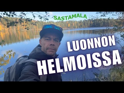 This independent outdoor vlog takes viewers to Ritajärvi nature reserve and, according to its description, follows the Valkeajärvi loop after the creator was encouraged by the city to visit and share an opinion. That makes it a personal trail experience rather than an official route bulletin. It complements the parish films by shifting from architecture to forest and lake scenery. Check the municipality's current path notices, weather and fire restrictions before setting out yourself.