Sassoferrato is best understood as two neighboring stories rather than one uninterrupted ancient town. The modern settlement climbs between the lower Borgo and upper Castello districts, while the Roman city of Sentinum lies a few kilometres to the southwest on a separate plateau. The distinction matters: Sentinum gives the area a deep archaeological past, but the town visitors walk through today took shape in the Middle Ages. Around it, the valleys and outlying communities preserve a third story, that of agriculture and the sulfur mine at Cabernardi.
A living municipality beyond its historic centre
The municipality had 6,797 residents on 1 January 2026, according to the latest Istat-derived population balance available for this profile. This figure covers the whole Comune, including its many hamlets and dispersed rural settlements; it is not the population of the small historic centre alone. The official visitor network still directs people to the IAT information point in Palazzo Oliva, in Piazza Matteotti, and to the town’s museums and cultural collections. A motorhome stop at Piazzale Dante is listed about 200 metres from the historic centre and 500 metres from the Rocca, a useful practical service for visitors travelling through the Apennines.
The town’s shape rewards a slow walk. The Castello quarter holds the fortified upper core and narrow lanes; the Borgo continues below it, so a visit involves slopes and changes of level. Begin around Piazza Matteotti, where the town hall, Palazzo dei Priori and Palazzo Oliva make a civic and cultural focus. The Rocca di Albornoz crowns the upper district, while churches and palaces reveal how a small mountain community accumulated art and public institutions over centuries. Uneven paving and steps are part of the terrain, so visitors with mobility needs should ask the IAT about access before planning a route.
Sentinum: a Roman city, not a foundation myth
The archaeological site of Sentinum gives Sassoferrato a significant place in the history of central Italy. The municipal account locates the Roman city on an alluvial plateau near the meeting of the Sentino and Marena waterways, close to the Via Flaminia and connected to it by a road that continued through Suasa toward the Adriatic settlement of Sena Gallica. Excavations have exposed sections of the walls, urban and extra-urban bath buildings, streets and other remains. The park’s visible structures are only part of a settlement whose wider urban fabric remains beneath agricultural ground.
The surrounding territory was a meeting zone for Umbrians, Etruscans, Gauls and Piceni, but the municipality is explicit that the nature of this cultural overlap is still being clarified. It also says that material evidence has not established whether a settlement stood on the exact site before the Roman city. That is a reason to resist a neat story of a town founded by one ancient people. Sentinum is associated with the Battle of the Nations in 295 BCE, during the Third Samnite War, but the modern hill town is not simply the same settlement under another name.
In the medieval period, the ruins supplied building material to nearby communities. Local municipal history places the foundation of a castle on a neighboring height around 1150, attributed to Count Atto, who came from the Castle of Galla near Genga. The settlement developed around the stronghold and became a free commune in 1460 after a period under the Atti counts. A later landmark is the Rocca commissioned by Cardinal Egidio Albornoz in 1365; the municipality says its construction was financed from the sale of property confiscated from the Atti family. These dated episodes offer a documented outline without pretending that every stage of the town’s growth is fully known.
Archaeology, painting and collections
Palazzo dei Priori, built in the fourteenth century, houses the Civic Archaeological Museum. Its displays connect finds from Sentinum with daily life in the Roman city: sculpture, inscriptions, coins, pottery, domestic objects and a reconstruction of the celebrated battle. The museum also helps visitors understand why some famous works are no longer in Sassoferrato. The Aion mosaic discovered at Sentinum is now in Munich; the civic museum shows a full-size reproduction, while a fragment of another large mosaic depicting tritons is among the local displays. The Perottiana collection adds Byzantine and Flemish reliquaries, including a small late-medieval mosaic icon of Saint Demetrius.
Art continues at Palazzo Oliva, where the Civic Art Collection includes works from the fifteenth to eighteenth centuries and the collection of Marche printmakers. The town is also closely associated with Giovan Battista Salvi, the seventeenth-century painter known as Il Sassoferrato. Together with churches such as San Francesco and Santa Chiara, these collections make the visit more than an archaeology stop. The Abbey of Santa Croce dei Conti, outside the compact upper centre, offers another Romanesque destination; confirm its opening before making a detour, since religious buildings do not necessarily follow museum hours.
Cabernardi and the landscape of work
About ten kilometres from Sassoferrato, the hamlet of Cabernardi tells a very different history. Sulfur extraction began there in the 1870s and transformed an agricultural area into an industrial community that drew workers from Sassoferrato and neighboring towns. The mine museum, housed in a former school, preserves tools, lamps, gas masks, plans, mineral samples, photographs and newspaper records. The adjoining open-air archaeological-mining park interprets installations such as the Donegani shaft and the Gill furnaces, helping visitors follow the stages of extraction and sulfur processing.
The site also preserves a difficult labor history. In 1952, after plans to cut employment, miners occupied the workings for forty days in what became known as the struggle of the “Sepolti Vivi,” or “Buried Alive.” The mine finally closed in 1959. These are not decorative anecdotes: they explain why the landscape, museum and community memory are intertwined. Today, the Pozzo Donegani walking route and the annual Palio mine festival connect the former industrial site with the four local districts. Dates and guided access change, so check the visitor service before traveling to Cabernardi.
Planning a visit and reaching the town
Fabriano is the nearest useful rail gateway. From its railway station, the regional ATMA VI1 bus runs on the Fabriano–Sassoferrato–Pergola corridor and lists stops at Sassoferrato and Cabernardi. The timetable varies by weekday, school calendar and season; confirm the correct service and return journey before setting out. A car makes it easier to combine the historic centre with Sentinum, Cabernardi and the outlying abbey. In the town, the IAT can advise on museum access, reservations for the archaeological park and current events. Plan time for both districts rather than rushing from the Rocca to the ruins: Sassoferrato’s appeal lies in the distance between those layers, and in the way a working community has kept each of them visible.
 Three views of Sassoferrato: the town, Roman Sentinum and Cabernardi’s mine
 HISTORY & ART SECRETS published this 5-minute-3-second video on 2 July 2025. Its title identifies the subject as the archaeological park of Sentinum at Sassoferrato, making it the most site-specific item in this selection. It offers a focused audiovisual companion to the Roman chapter of the town guide, while the local archaeological and museum sources remain the reference for chronology and interpretation. Sentinum lies outside the present historic centre, so viewers should not mistake the ancient site for the medieval streets around the Rocca. The video is an introduction to the subject, not a current visitor notice.
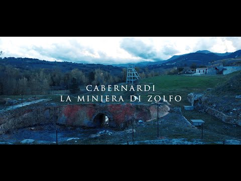 Fabio Fermi published this 1-minute-18-second video, titled “CABERNARDI LA MINIERA DI ZOLFO,” on 26 November 2019. The description identifies the sulfur-mine museum near the former Cabernardi workings and names Montecatini as the company that operated the mine. Its brief format makes it a compact entry point to the industrial story behind the museum and open-air mining park; it cannot provide a complete account of the miners’ 1952 occupation or the closure that followed. Use it alongside the documented local heritage interpretation, and check the visitor service for present access and guided-tour arrangements.