Rosheim stands where Alsace’s vineyards meet the first wooded slopes of the Vosges. The town looks toward the plain on one side and Mont Sainte-Odile on the other; its medieval centre remains part of an everyday community rather than an open-air set. Residents use the old streets, associations and municipal services shape local life, and each Friday food traders and artisans gather at the market. The visitor finds a place whose Romanesque identity can be read in stone, but whose story also includes defensive walls, religious change, railway building and a varied modern economy.
INSEE’s 2023 reference figures record 5,457 municipal residents in the entire commune and a total population of 5,542 when people counted separately are included. These figures took effect on 1 January 2026. They describe the municipality, not just the old centre. Rosheim is also the seat of the intercommunal community that brings together eight neighbouring communes, making it a service and employment centre as well as a heritage stop.
A settlement with a documented name, not a single founding date
The municipal history says the area was occupied in prehistoric times and records Rosheim’s first written mention in 778, under the name Rodashaim. That is a documentary milestone, not proof of the exact year the town began. Archaeology at the nearby Purpurkopf has produced Roman pottery, but the municipality does not treat it as proof of a Roman fort or a Roman foundation for Rosheim. Excavations there from 2021 to 2023 instead identified substantial remains of a fortified site, including a large rectangular tower dated to the ninth century. Its connection to the name Burckberck in an eleventh-century text is part of the current interpretation; the site’s full story is still being investigated.
In the Middle Ages, Rosheim developed in three connected quarters: the fortified Mittelstadt at the centre, the Niederstadt below it and the Oberstadt above. A first wall protected the central area from the middle of the thirteenth century; a second, larger enceinte enclosed the whole town about a century later. Surviving gates and towers make those layers visible on a walk. Rosheim became an imperial city in 1303 and joined the Decapole, the league of ten Alsatian imperial cities, in 1354. Those political links helped shape its growth, although they should not be mistaken for uninterrupted prosperity. The Thirty Years’ War brought destruction; the town’s eighteenth-century rebuilding included Saint-Étienne church and the town hall.
Read the Romanesque centre at walking pace
Begin at the church of Saints Peter and Paul, the landmark that gives Rosheim its “Romanesque city” identity. The municipality dates most of the building to 1132–1290 and describes its yellow local sandstone as a defining material. The tower was completed in the thirteenth century, when its large openings already point toward Gothic forms. Outside, animals and fantastic creatures crowd the carved stone. The municipal interpretation reads them as warnings about danger and temptation; inside, the decoration becomes quieter, with human figures and a capital bearing twenty-one heads. Looking closely is more rewarding than passing through for a quick photograph.
A short walk away, the Maison Romane gives the religious monument a domestic counterpart. Built in 1154 and protected as a Monument historique since 1921, it is described by the town as the oldest preserved house in Alsace and among the oldest in France. Its thick stone walls can suggest a defensive tower, yet the building was primarily a home on a commercial street. The cellar served storage, the first floor daily life, and the upper level supplies and sometimes sleeping space. A fireplace, latrines and a large twin window show the comfort available to a well-to-do medieval household. The identity of its owners is not established; local interpretation suggests notables, religious representatives or wealthy merchants rather than naming a specific person.
Continue to Saint-Étienne, where the medieval and later town meet. A parish probably existed by the eighth century, but the present church is not that early building: its thirteenth-century predecessor was largely demolished around 1780, leaving the Romanesque bell tower. Architect Nicolas-Alexandre Salins designed the replacement in a neoclassical style, with four Doric columns. Late eighteenth-century furnishings by Jean-Baptiste Pertois and statues of Saint Odile and Saint Arbogast give the interior its own period character. The municipality offers guided visits combining these churches with the Maison Romane, medieval walls and Renaissance houses; reserve and check current access.
Walls, a six-bucket well and the working town
The old centre rewards a route rather than a checklist. Remains of the inner wall are visible near the Clock Gate, the School Gate and Rue de la Marne; the later outer defences survive most clearly at the Virgin Gate, Lion Gate and Sainte-Marthe Tower. Place de la République adds the town hall and its distinctive six-bucket well. The former prison, built in 1885 in pink sandstone beside the old inner wall, offers another layer, though opening arrangements should be checked before planning an interior visit. On Fridays, the weekly market runs from about 7 a.m. to 1 p.m. along Rue du Général-de-Gaulle, between Saint-Étienne and the Clock Gate. Butchers, fishmongers, cheesemongers, greengrocers, prepared-food vendors and artisans make it a window on present-day Rosheim, not merely a medieval backdrop.
Employment data also underline that the town is more than tourism and wine. INSEE’s 2023 workplace breakdown records jobs in commerce, transport and services, public administration, education, health and social care, industry, construction and agriculture. Commerce, transport and services form the largest group; industry and construction remain substantial, while local planning documents identify vineyards and agriculture as continuing parts of the landscape and economy. Rosheim’s position between wine-growing foothills and the Strasbourg–Molsheim corridor helps explain that mix. Its identity is built from local services, working businesses, heritage and wine country together.
Follow the old railway into the hills
For a longer outing, the Voie Verte des Portes Bonheur, also called the Chemin des Carrières, follows the former railway from Rosheim toward Saint-Nabor. The 11-kilometre greenway passes through the landscape around Boersch and Ottrott, with contemporary artworks designed by architect Reiulf Ramstad, open views and varied natural settings. The line once carried stone from the Saint-Nabor quarries to the plain; its conversion turns industrial history into a walk, cycle ride or rolling route. The local tourism office lists bicycle hire and can advise on route conditions and nearby loops. Allow time for the return or plan a loop in advance.
The wooded Purpurkopf is another excursion for visitors interested in archaeology, but it is not a fully explained Roman site: its ninth-century fortifications are the principal result so far, and research continues. Mont Sainte-Odile, the wine-route villages, Boersch, Ottrott, Obernai and Molsheim broaden the itinerary. Strasbourg is the main city connection. Rosheim station has TER ticket machines, a secure bicycle shelter and free car parking, but no staffed ticket office. Direct TER trains link it with Strasbourg; SNCF’s journey planner showed a direct trip of about 31 minutes on 12 October 2026, with times varying by departure. Check the current timetable and service notices. A day visit is possible, while the walking circuit, market, greenway and nearby wine villages give good reason to stay longer.
 Rosheim in three films: Romanesque heritage, a medieval home and the old railway path
 France 3 Grand Est visits the Maison Romane during the 2023 European Heritage Days and follows a guide through the stone house built in 1154. The report helps viewers understand how an exceptional medieval residence worked as a home, with its levels and surviving architectural features. It is a focused heritage feature, not a promise that the house is open every day; check the town’s current visitor schedule before planning an interior visit.
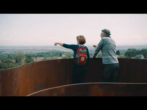 The Mont Sainte-Odile intercommunal tourist office introduces the Portes Bonheur greenway, a former railway route between Rosheim and Saint-Nabor, through Boersch and Ottrott. The one-minute film highlights the path’s combination of nature, art and industrial heritage. It is useful for choosing a different pace after the old town, but it does not replace current route-condition information or a map for the return journey.