Rääkkylä is best understood from the water outward. In this municipality of North Karelia, the northern reaches of Lake Saimaa break into bays, islands and long shorelines; the inhabited villages are scattered through a countryside where a trip to the next place can feel like part of the destination. Statistics Finland counted 1,830 residents across the whole municipality on 31 December 2025. That is the population of the municipality, not just the compact church village. In summer, holiday homes, visiting cyclists and cultural events add another rhythm to the lakeside roads.
The place has an unusually visible cultural life for a small rural municipality. Folk music, the kantele, local theatre and village associations are not merely items on a visitor brochure: they help explain how the communities keep gathering across a wide, island-dotted territory. The annual Kihaus Folk festival makes that tradition public, while workshops and local makers bring it into everyday life. Rääkkylä rewards a visitor who slows down, follows the shoreline and treats its separate villages as parts of one larger landscape.
A village landscape shaped by the lake
Rääkkylä is not a single old-town centre surrounded by empty countryside. The church village, Oravisalo and Varpasalo, Rasivaara, Haapasalmi and other settlements each have their own relationship with the lake and the road network. Islands are connected by bridges and by the Nestori cable ferry across Arvinsalmi between Oravisalo and Liperi. The ferry is also a practical reminder that this is a lived archipelago, not a scenic backdrop arranged only for visitors.
For an overview on foot, the municipality lists the Saviniemi nature trail at about four kilometres and the Kuismin trail at about ten. The Oravilahti route is around six kilometres, and Savilahti Trail is a five-kilometre mountain-bike route near the church village. Across the islands, the Saaristo Trail can be planned as a loop of up to about fifty kilometres, with shorter alternatives. These distances and trail conditions should be checked against the current municipal maps before setting out; lakeside weather and seasonal maintenance matter.
Birdwatchers have a reason to pause at Oravilahti, where the Lintulinna observation tower overlooks a broad open landscape used by birds during migration. The shore, fields and wet areas make the view change with the season. It is a quieter experience than a festival, but it shows the same local character: daily life and nature remain close together here.
What the records say about Rääkkylä
The written history of the municipality is clearer than its popular origin stories. The present wooden church was completed in 1851 on the highest point of the church village. In 1857, an imperial decree provided for Rääkkylä, Oravisalo and Hernevaara to form an independent parish, separating the congregation from Kitee’s parish administration. The municipal self-government reform came later: Finland’s 1865 rural-government decree did not produce an immediate local meeting. Rääkkylä’s first municipal assembly took place on 6 January 1874 in the Kinnula house, after the governor ordered it to convene. The municipality dates its foundation to 1874.
That distinction matters. A local place-name explanation says Rääkkylä may have developed from the Swedish expression “brödby”, or bread village, because slash-and-burn cultivation supplied grain. Another explanation connects the name with “rääkkyrauta”. The municipality itself presents these as competing accounts, not a settled etymology. Its coat of arms, with crossed charred logs and flames, does make the historic importance of slash-and-burn farming visible. The image is evidence of how the municipality chose to represent its rural past, rather than proof of the name’s origin.
The municipality and Rääkkylä-Seura have also created eleven “story stops” around the area, a self-guided way to encounter local history in the landscape. They were first assembled for the municipality’s 150th-anniversary programme in 2024 and remain useful for visitors exploring the villages. At the church village, the local-history museum preserves the material culture of farming households; it is run by Rääkkylä-Seura and is open by arrangement, so contact the association before making a special trip.
Church, mill museum and wartime traces
The 1851 church is the most prominent landmark in the centre. It is an active parish church rather than a museum building, and winter access is limited. During summer, visits can be arranged through the parish office in Kitee. The municipality also marks the memorial and object display for Esa Pakarinen, born in the village of Hernevaara in 1911. He became a much-loved Finnish stage performer and film actor. His memorial stands near the municipal hall, and the display is housed on the hall’s second floor; the municipality lists weekday opening hours, but visitors should verify them before arrival.
At Paksuniemi, the old mill-and-dairy setting gives a different view of local work and leisure. The municipality says the mill museum includes, among other things, a replica of a sewn-plank boat dating to the twelfth century, and it hosts changing art exhibitions mainly in summer. The wider harbour area is a visitor base with marina, caravan pitches, sauna and seasonal food service. It is a natural place to begin a cycling day or simply spend time by the water, although services and opening dates are seasonal.
In Oravisalo, the Salpapolku path follows a section of the Salpa Line, Finland’s Second World War defensive line. The three-kilometre route includes a dugout, trenches and a dugout sauna. It is a tangible site of twentieth-century military history, not a reconstructed battle scene. Visitors should respect the structures, stay on the marked route and check local access information. Nearby Kivisalmi has memorials that recall the finding of ore, the promotion of the Rääkkylä–Liperi road and the building of a canal, showing how transport and resource extraction also shaped the islands.
Music, kantele making and the local economy
Kihaus Folk is the municipality’s best-known annual gathering. Its programme combines Finnish and Karelian folk traditions with contemporary performers, workshops and community events. The festival marked its thirty-fifth year in 2026. Rääkkylä’s cultural strategy and the local music scene also include amateur music-making, music education and theatre; these are part of the place’s year-round identity, not just a summer show. Event dates change, so consult the festival programme for the year of travel.
Kantele making gives that musical identity a working craft dimension. Koistinen Kantele’s workshop is located in Rääkkylä, where the company builds and maintains instruments. Its address is not, by itself, confirmation of public walk-in access or a guided factory visit; contact the maker first if you hope to see the workshop. Nearby makers and the festival together offer a way to understand how a traditional instrument remains part of current music.
The municipality’s published overview describes a mixed rural economy: agriculture and forestry, processing industries and services all have a role. It lists roughly 160 businesses and names cultivated mushrooms, including shiitake, windows and doors, and metal- and wood-processing products among local industrial outputs. These are municipal summary figures rather than a new census of jobs. Tourism is being developed around the archipelago, outdoor routes, accommodation, cultural events and food, but the scale remains local: check what each business is actually operating during your dates.
Getting there and building a useful visit
Rääkkylä lies about sixty kilometres from Joensuu by the regional road network; Kitee is roughly twenty-five kilometres away and Liperi about forty. The nearest railway stop identified by regional tourism information is Tolosenmäki in Kitee, while Joensuu is the nearest airport. These are approximate distances, and the route you choose depends on the village or island you are visiting. From Joensuu, the bus timetable varies by day and season. Rääkkylä’s municipality publishes regional bus information and a weekly service taxi from villages to the centre; the latter must be ordered from the route operator by 6 p.m. on the previous day.
For an island circuit, drive or cycle toward Oravisalo and cross Arvinsalmi on the Nestori ferry to Liperi. The local ferry operator publishes service details and scheduled breaks; check these before departure, especially if you are travelling with a bicycle or planning a timed connection. A first-time visitor could spend one day around the church village, Paksuniemi and Saviniemi, then reserve a second day for Oravisalo, Salpapolku and the ferry crossing. In July, Kihaus may be the reason to time a visit; outside festival season, the trails, harbour and village museums provide a quieter introduction. Confirm bus, ferry, museum and business opening times for the exact dates of your trip.
 Rääkkylä on film: lakeside calm, cycling routes and Kihaus Folk
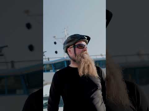 This short Saimaa by Cycle clip is a concise orientation to cycling in Rääkkylä. Its description places the routes in the landscape associated with the Finnish film Onnen maa and names Paksuniemi harbour and the Rasivaara sports field as starting points. That specificity is its practical value: it gives a visitor two real places from which to begin planning. At just over half a minute, it is an invitation rather than a route guide; it does not replace maps, distance details or current trail conditions. Use it to choose an area, then consult the municipality route information before riding.
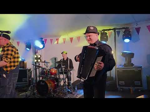 This 2025 recording brings Kihaus Folk into the video set through a performance identified in its title as Tiekarhut YHTYE. The uploader labels it as music from Kihaus in Rääkkylä, so its value is cultural rather than navigational: it offers a sample of the festival live-music setting and complements the municipality wider reputation for folk traditions. The long-form recording is suited to viewers who want to spend time with the performance, not only scan a short promotional clip. The title and description provide limited programme context; check the official Kihaus programme for artist details, venue information and future dates.