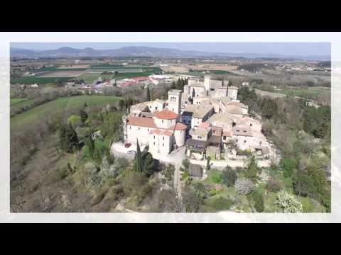
Puygiron occupies a low hill above the Jabron and the Valdaine plain in the Drôme. The village’s official guide describes the ridge as a belvedere over the Rhône valley and the Drôme foothills; its narrow streets preserve carved stone around door and window openings. The municipality counted 431 residents across the entire commune in 2023, at 64.5 people per square kilometre. That figure belongs to the commune, not just the historic cluster around the château. Puygiron is compact enough to read on foot, but the view also makes clear how the settlement sits between cultivated lowland and surrounding hills.
Two sites in the village’s history
The municipality’s local history places an earlier medieval settlement at Saint-Bonnet, close to a Carolingian priory and on the site of a Gallo-Roman villa. Its account says that this first village was abandoned in the 13th century and that residents moved up to “le puy”, under the château’s protection. A Drôme Provençale tourism page tells the sequence differently, saying the move toward the present hilltop took place from the 14th century. The sources therefore support a medieval relocation, but not a single agreed date; the article keeps that distinction visible.
The château defines the present skyline. The town’s guided-visit page dates it to the late 12th or early 13th century and describes a rectangular plan with four towers, one serving as a keep, plus a guard room with a large fireplace and a Renaissance courtyard tower. A state-filed heritage assessment, however, describes it as 13th/14th century. That difference should not be hidden behind a falsely precise date. The same state assessment records the château as inscrit (listed) as a historic monument on 12 June 1957; this is the legal status used here, although the municipal page uses the less precise word “classé”. The listed Chapelle Saint-Bonnet stands at the older settlement site. The state assessment gives an 11th-century date and inscription on 25 June 1929, while tourism material describes it as 12th century. Check with the municipality or tourism office for any organized interior visit; a route passing the chapel does not guarantee that it is open.
Fields and a walk to Saint-Bonnet
Puygiron’s setting is not only architectural. The commune’s 2022 land-use plan described roughly 231 hectares of utilized agricultural land, a little under half its area, in a mixed landscape of cereals, oilseed crops, aromatic plants such as lavender, orchards and truffle groves. This is a dated planning baseline, not a claim that the same acreage was resurveyed in 2026. Insee’s latest published local tables add another careful snapshot: the commune had 75 jobs located within its boundaries in 2023 and six employer establishments at the end of 2024. The latter are very small counts; they should not be read as a complete map of local work or commuting.
The marked Coste Chaude circular walk is a practical way to connect the village and countryside. The Drôme department’s route card, updated on 27 September 2026, gives 6.91 kilometres, an easy level, about two hours and 100 metres of positive ascent. It begins and ends at Puygiron, circles the Coste Chaude high point, follows lavender fields and reaches the Saint-Bonnet chapel before returning toward the village. Conditions can change with weather, seasonal work and trail maintenance, so check the current route sheet before leaving and carry water in warm weather. The château’s interior access is not guaranteed by this outdoor itinerary. The municipality’s guide and the Drôme tourism listing provide current visitor context; confirm any special visit dates or opening arrangements in advance.