Oulainen is a compact Northern Ostrobothnian city where a river, a railway and everyday services meet. The Pyhäjoki runs through the centre; the Ostrobothnia railway and highway 86 also cross the town, making it a useful stop between the coast and the inland towns of the river valley. Oulainen counted 6,912 residents on 31 December 2024, according to the municipality's 2026 budget. The city describes itself as a community of about 7,000, with regional health, rehabilitation and education services alongside an active industrial sector. A visit here is less about a single monument than about seeing how landscape, work and community life fit together in a small northern town.
Meet the river and the open landscape
The Pyhäjoki gives the centre its strongest natural feature. At Oulaistenkoski the river is used for outdoor recreation, including paddling and fishing, while the municipal nature guide lists several quieter places for a longer outing. The Isojärvi–Ahvenlampi trail is about four kilometres long and passes through varied terrain of mire, rocky ground and leafy woodland, with interpretation boards along the way. The city describes the trailhead as an additional drive from the Ylivieska road, so it is worth planning transport before setting out.
Birdwatchers can look toward Likalanjärvi, an approximately 80-hectare lake with a tower on its northern shore. Piipsjärvi offers swimming and fishing, and winter activities when conditions allow. For a wilder setting, Hirvineva is a large, mostly open mire within the Natura 2000 network; Iso and Pieni Honkaneva form another protected mire landscape. The city identifies Piurukkaneva as a bird-rich raised bog, with around 30 wetland species recorded breeding there. These are sensitive habitats: use marked access and follow local conservation guidance rather than treating every open area as a casual walking route.
A town shaped by work and community memory
Oulainen's formal municipal history begins in 1865. It became a market town in 1967 and received city status in 1977. Those dates describe changes in local government, not the beginning of human settlement. The town's identity is also visible in its coat of arms: a golden upright crab on green, recalling a historically important local crayfish catch. The river is not just scenery in that story; it helped shape livelihoods and the way people understood the place.
At the Wanha Woima heritage centre, the local museum is housed in a former grain store built in 1908. It has served as a museum since 1956 and moved to the heritage-centre grounds in 2012. Displays focus on local livelihoods and leisure around the turn of the nineteenth to twentieth centuries, with a scale model of Oulainen as it looked in 1950. A small fragment of an eighteenth-century ceiling painting from the church is another reminder that local history is held in individual objects as well as official milestones. Nearby, the Oulaskangas museum presents the history of the hospital from 1914 and material connected with the former Visala psychiatric hospital. Confirm opening arrangements before visiting either collection.
Festivals, machinery and music
Oulainen's calendar brings heritage out of the museum. Waltakunnalliset Wanhan Woiman päivät, held in summer at the heritage centre, celebrates rural culture and the preservation of old machinery and skills. The gathering is built around demonstrations, exhibits and community participation, so it offers a different perspective from a conventional museum visit. In autumn, Oulaisten Musiikkiviikot adds concerts and performances to the season. Dates, venues and programmes change, and the city's events calendar is the best place to check what is happening during a particular trip. Oulainen is also part of the wider Oulu2026 cultural programme.
The town works well as a base for combining small-scale cultural visits with time outdoors. The 320-kilometre Flatland Route links Oulainen with coastal villages, river landscapes, local services and heritage stops on quieter roads. It is designed as a multi-day cycle route, though visitors can ride a shorter section and continue by train. For a single day, choose one nature area, then return to the centre for food or an event rather than trying to cover the whole municipality at once.
Getting there and planning a stay
Oulainen is served by trains on the Ostrobothnia line and by intercity buses. Highway 86 connects it with towns including Ylivieska and Raahe; municipal information also lists bus services toward Oulu and other nearby centres. The railway station is in town, but check the specific train's stops, travel date and accessibility before booking. Bus services and connections vary by weekday and season, so use the current Matkahuolto or VR journey planner rather than relying on old timetables. Oulu Airport is less than 100 kilometres away according to the city, while Raahe and Kalajoki ports are each around 60 kilometres away.
The municipality's visitor page gathers accommodation, food and transport contacts, but businesses may have seasonal hours. If you want a guided town walk, the city lists a local guide by appointment. Build in time for distances: the riverfront, museums, nature trail and mire reserves are separate stops, and some require a car or advance transport planning.
 Oulainen videolla: kaupunki, teollisuus ja Wanha Woima
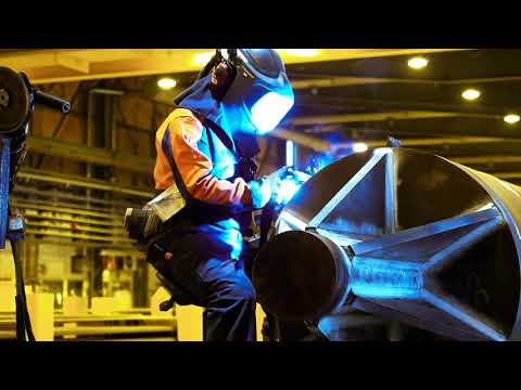 This short factory film moves from the town as a whole to one part of its working life. SSAB identifies the site as its Oulainen tube factory and says it produces spiral-welded steel pipes, including value-added products. The 2017 recording is a useful introduction to the industrial presence that the municipality also cites as part of local vitality, while its age means it should not be treated as a current guide to production, jobs or factory access.
 Tonantza's recording documents the tractor parade at the Wanha Woima event in Oulainen on 3 July 2026. Its title and description identify the event and mention a Valmet 20 MT among the machines noticed by the uploader. That makes the film a timely complement to the town's local-heritage museum: it shows the machinery tradition as a public gathering, rather than a static collection. Event dates and access arrangements change from year to year.