Merijärvi is a North Ostrobothnian farming municipality whose centre sits on an unexpectedly revealing strip of land. The village stands between the former basins of Tähkijärvi and Merijärvi, both drained and turned into farmland. The fields are therefore more than a rural backdrop: they mark a major change in how people used the landscape. Statistics Finland recorded 1,031 residents across the municipality on 31 December 2025. Its villages and visitor sites are spread over a broad area, so a day here works best when planned around a few connected stops rather than a single walk through a compact town.
A church village shaped by water and work
Merijärvi became a municipality in 1866, but its church community predates that administrative boundary. Local residents received permission to build a church in 1779, and the wooden cruciform church was completed in 1781 under master builder Simon Jylkkä-Silvén. The separate bell tower followed in 1799. Inside are two layers of art: Thomas Kiempe's late eighteenth-century first altarpiece remains in the south transept, while the current altarpiece, painted by Jeremias Alin, dates from 1877. The church stands in a quiet, stone-walled graveyard that is also a small memorial park, with war graves and a monument to victims of the famine years.
The story of the lakes deserves a literal reading: they were drained for fields, not lost to a natural disappearance. The municipality's visitor account offers no single date for that transformation, so it is better understood as a landscape process than assigned an unsupported year. Likewise, Tanskaperä's ancient double burial is listed among local sights, but the visitor page does not give its date or archaeological interpretation. It is a reason to learn more locally, not evidence for a Roman, Greek or other ancient founding.
Farm courtyards and a museum season
In Kalapudas, the old farm cluster shows how households grew around an original holding. The municipality calls this arrangement a puhto: as land was divided among descendants, new homes formed close to the parent farm. The cluster is also included in Finland's inventory of nationally significant built environments. Rantapudas is described as the oldest surviving main house, from the early 1700s; nearby buildings include a granary dated 1808, Alapudas from 1864 and the former Ylimäki, now called Kalapudas, built in the 1880s. The architectural interest lies in the grouping of dwellings, barns and shared yard spaces. These are village homes, not museum rooms, so admire the setting from public roads and respect residents' privacy.
Next to the church, Merijärvi's local-history museum occupies a former loan-grain store. Its objects illuminate older farm and household life, and the municipality opens it in summer; ask the leisure office for the current dates before travelling. Farther away in Pyhänkoski, Tähjä's local-history house is an old farmstead that the municipality traces to 1695. Its principal house dates from the early nineteenth century, while a loft granary is dated 1782. Today the buildings host events and private functions, with visits arranged through the local history association rather than regular walk-in hours.
Pyhänkoski's gorge and the Ristivuori seasons
The Pyhäjoki cuts through the landscape at Pyhänkoski, where the municipality describes a steep-sided, rock-walled gorge and a 22-metre drop measured from its highest point downstream. The easiest place to look is the bridge on connecting road 7890. It is a striking stop even without a long hike, but the river itself is not a casual swimming or paddling venue; the viewpoint does not certify water conditions or access below the bridge.
Ristivuori gives visitors a reason to stay longer in the same village. The municipal outdoor area has about eight kilometres of trails, a three-point-nine-kilometre illuminated ski track in winter, a marked route toward the church village and a short ski slope with equipment rental when operating. There are fire sites and a log cabin that can be booked through the local 4H association. The network changes character by season: paths suit walking or cycling on bare ground, while winter brings ski trails and a volunteer-run slope. Accessibility has not been formally surveyed, and some terrain is difficult for wheelchairs. Check snow, trail and lift conditions before setting out.
For a gentler summer pause, the municipality lists beaches at Lahdenlampi near the centre, Kalapudas and the former quarry at Pyhänkoski. Water quality is monitored during the bathing season. The quarry pool reaches a listed maximum depth of eight metres, so it should not be treated as a shallow family pond. Bring the current water-quality notice and check each beach's access and facilities.
Rural livelihoods and practical connections
Agriculture remains part of Merijärvi's working landscape, while the municipality also maintains business premises, plots and support for small enterprises. Farms, forest, municipal services and local businesses connect the village to a wider regional economy; this is not a resort where every service is organized around tourists. The centre has a local-history museum, church and everyday public services, but opening hours for museums, the ski slope, rentals and seasonal facilities vary. It is sensible to check meals, fuel and supplies before leaving the larger service centres nearby.
The municipality places Ylivieska, Kalajoki and Oulainen about a half-hour drive away; Oulainen has the nearest railway station identified in the municipal travel guide. Roads connect Merijärvi with these neighbouring centres, and the bus schedules are available through Matkahuolto. Oulu and Kruunupyy airports are each around 100 kilometres away. A train journey therefore needs a road or bus connection for the final leg. Confirm the current stops and timetables with the operator, especially outside the school term. With a car, a natural circuit is the church and museum, Kalapudas' farm landscape, Pyhänkoski's river gorge, and Ristivuori's trails, returning through the open fields that once held the lakes.
 Merijärvi kolmessa videossa: paikallishistoria, kirkonkylä ja Pyhänkoski
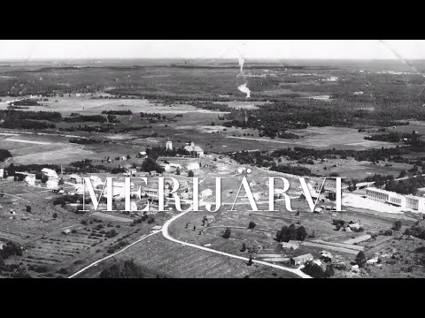 In this short aerial comparison, the creator places a recent drone image of Merijärvi's centre beside and over a 1959 photograph taken from the same viewpoint. The description highlights how the village street changed over six decades, making the film a quick visual companion to a walk through the church village. It is a personal before-and-after comparison, not a full architectural inventory or a substitute for the municipality's heritage records.
 This 32-second clip is identified by its creator as a kayak descent at the Pyhänkoski rapid in June 2014. It gives a brief impression of the water feature that the municipality describes as part of a rocky gorge on the Pyhäjoki. The recording is old and very short; it is not safety guidance, a current river-condition report or an invitation to attempt the descent without suitable expertise.