A small municipality opened by its river
Alavieska lies in Northern Ostrobothnia, where the Kalajoki cuts through an open, low-lying plain. Statistics Finland counted 2,384 residents in the municipality on 31 December 2025; that total covers the surrounding villages as well as the centre. The river is the clearest guide to the settlement: the church village grew beside its banks, while fields and smaller communities spread across the flat countryside. Agriculture remains a defining part of local life, alongside wood and metal industries named by the municipality.
The landscape feels broad rather than dramatic. Its interest comes from the relationship between the river, cultivated land and the village network. Alavieska is a place to explore at a slower pace: a walk by the water, a look at the churchyard and a short drive or bus ride to a village give a more truthful picture than a checklist of monuments.
What the name says—and what it does not prove
Alavieska became an independent municipality in 1879. The municipality explains that the old word “vieska” referred to a calmer point above or below rapids where a river could be crossed more safely; Ala- and Ylivieska were named for their positions along the Kalajoki’s flow. It also preserves a local tale about the Jotuni brothers, who were said to have fled into the forest and replied “we will stay and ponder a little longer” when asked to return. The story is folklore, not a documented founding event; the municipal account itself separates it from the linguistic explanation.
The river also reflects practical choices made over generations. Municipal planning material records the drainage of Alavieskanjärvi between 1833 and 1848 and the creation of Järvioja, also called Kalliokanava. The channel belongs to the history of making wet ground usable for farming. It is a reminder that the apparently natural plain has been shaped by work, not an advertised trail or guaranteed visitor site.
A church and a former parish house
In the centre, Alavieska’s brick church was completed in 1948 from plans by J. Karvonen. A carved Christ by local artist Hugo Kähtävä serves as its altarpiece. Beside it stands a wooden bell tower built in 1738 and moved to this setting late in the eighteenth century. The pairing gives the churchyard a particularly layered appearance: the present building belongs to the post-war period, while the tower reaches back to an earlier congregation. The parish asks visitors to arrange access in advance.
The local-history museum is housed in a former parish staff building on Papinpolku. Its exact construction date is uncertain: the municipal study gives a mid-eighteenth-century earliest estimate but considers a late-eighteenth-century date more likely. Objects began to be collected in 1969, and the local association had started museum activity earlier in the decade. The building’s changing role—from parish household to museum—makes it a human-scale way into the area’s religious and everyday history. It opens seasonally, so confirm the current hours before planning around it.
Walks beside the Kalajoki and beyond
Pappilanniemi is the easiest nature break from the centre. The municipality describes it as a riverside recreation area near the parish hall and Omavieska. Filippuksen polku follows the bank, crosses Pääskynoja on an arched bridge and reaches a lean-to shelter at the peninsula tip, with views toward Haarainkoski and Koskelan mutka. This is a modest local walk rather than a long wilderness trek; it works well between the church and the museum.
For a different landscape, the Ryökönkangas old-forest trail lies by the road between Taluskylä and Someronkylä. The municipality describes old, large trees and a more wooded character. The villages themselves add context: Käännänkylä has a recorded settlement history reaching the 1550s, and the city notes that river power supported milling and sawmilling there. Check trail conditions and access before setting out, especially after rain or in winter.
Services, nearby towns and arrival
Alavieska’s centre brings together its parish, library and municipal cultural venues, with shops and everyday services serving both residents and nearby villages. The museum and village attractions do not operate like a large visitor complex; opening arrangements are local and often seasonal. Ylivieska is the nearest major rail gateway: the municipality gives the road distance from Alavieska as 18 kilometres, with Kalajoki 25 kilometres away. A current Wiimax route connects Hiekkasärkät and Kalajoki through Alavieska to Ylivieska, and the published timetable is valid from 3 August 2026 to 6 June 2027. Departures vary by weekday, school day and season, so check the carrier’s current planner before travelling. A car makes it easier to combine the central river walk with the outer villages.
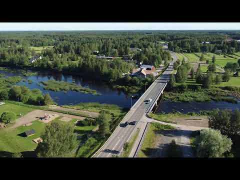 Alavieska in three films: a municipal welcome, market day and river walk
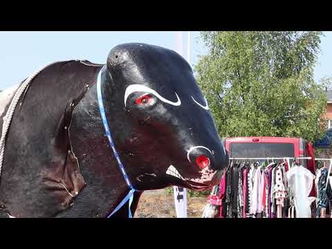 The municipality’s “Alavieskan markkinat 2021” documents a particular market event, not an annual schedule. It gives the video a useful community perspective: the market is presented as a gathering in local life rather than a permanent visitor attraction. Anyone hoping to attend a similar event should check the municipality’s current calendar instead of relying on the 2021 date or assuming the same programme continues.
 “Pappilanniemen kuntorata ja virkistysalue,” from the municipal channel, is the most practical of the three for a short riverside outing. Its subject matches the municipality’s description of Pappilanniemi as a recreation area beside the Kalajoki. Use the video as a visual introduction, then check current access, path condition and local guidance before visiting, especially in wet weather or winter.