A southern landscape shaped by water
Lemland occupies the southern part of Åland’s main island, close to Mariehamn but edged on every side by bays, channels and open sea. The municipality counted 2,139 residents on 31 December 2025; that figure covers the whole municipality, including its villages and smaller islands, not just Söderby or another centre. Water is not a decorative border here. It shaped the routes that brought seafarers to medieval chapels, the canal that still interrupts the road network and the harbours that connect the outer islands to the rest of Åland.
The first impression can be a short drive from Mariehamn, but Lemland rewards slower movement. A visitor can start at Lemströms canal, follow the inland village road to the medieval church and then continue toward a shore trail, a farmstead museum or a sailing harbour. The landscape changes quickly: open fields and village yards give way to rocky coastline, wooded meadows and sheltered anchorages. A car or bicycle makes it easier to link these dispersed places; boat destinations require separate planning.
The canal: a working cut through the island
Lemströms canal separates Lemland from neighbouring Jomala. It was constructed in 1882, and the swing bridge that now crosses it was built in 1983 and underwent major renovation in 2024–2025. The canal is only about 350 metres long, yet it makes a visible meeting point between road travel and coastal navigation. When boats pass, road traffic waits; when the bridge is closed, the maximum mast height is lower. Seasonal openings are set by the authorities and can change, so check the current notice before planning around a passage or a bridge opening.
The canal also has a cultural side. The painter Victor Westerholm’s studio and summer home, Tomtebo, stood nearby; he founded the Önningeby artists’ colony in 1886, bringing painters from Finland and Sweden to work in the surrounding landscape. The colony remained active until 1914. For visitors, that history adds another way to read the scenery: water, light and shore were not only routes and resources but subjects for artists. It is worth pausing at the canal rather than treating it only as a crossing.
Medieval faith and a harbour remembered in records
Lemland’s S:ta Birgitta church is one of the most striking medieval buildings on Åland. Archaeological work found the foundations of an earlier wooden church, but its exact age remains uncertain. Dendrochronology and building evidence place the stone nave’s decoration in the late 13th century and the west tower around 1317. Restored wall paintings from about 1290 fill the chancel with scenes from the lives of saints and the Passion. A Madonna and Child from the 1320s, a suffering crucifix from the mid-14th century and an altarpiece from the middle of the 15th century deepen the sense of a church shaped over generations, not built in one campaign.
Further east, the ruin of St Olof’s chapel at Lemböte marks an older relationship between worship and seafaring. The municipality describes the chapel as medieval and points to a protected natural harbour nearby. The harbour is mentioned in Valdemar’s Jordebok around 1250–1300. Local interpretation suggests that a busy international sea lane between Sweden and Finland made Lemböte a natural stop and explains why the chapel was built there. That is a plausible explanation, not a proven foundation story. Around the ruin, visitors can also see archaeological remains, including a burial field and stone features once associated with navigation.
Walk between villages, shore and nature reserves
Lemlandsleden is the municipality’s long-distance walking route: about 25 kilometres from Lemströms canal to Lumparsund, passing Lemböte, Knutsboda, Söderby, the church, Norrby, Bistorp and Granboda. Eleven information boards explain places along the way, and the route is marked in the landscape. It works well as shorter stages too. Check the map and trail condition before setting off, and respect the municipality’s request not to cross private residential or holiday plots.
At the southern end of the main island, Herröskatan offers a compact nature walk with marked paths, resting places and a bird tower over the surrounding sea. The protected area combines meadows, groves and coastal slopes; traces of fortifications and harbour structures from the era of Russian rule and the Second World War give the point an additional historical layer. Its plants and birdlife are sensitive, so visitors should keep to the path and follow the rules posted at the entrance.
Nåtö’s nature reserve provides another contrast: wooded meadows, a marked nature trail and a rich flora that changes with the season. These are places for walking and observation rather than collecting. On warmer days, the municipality’s map also marks bathing places such as Hellestorp and Klockarholmen. A short outing can pair one reserve with a swim; a longer one can connect the coast with a village stop and the church.
Seafarers’ homes and island harbours
Skeppargården Pellas, built in 1884 by shipowner Erik Petter Eriksson, turns maritime history into a domestic visit. The restored house preserves painted rooms and period furnishings, while farm tools, a working windmill and everyday objects show how a shipowner’s family lived ashore. It is presented as a living museum rather than a static collection, and its public opening is seasonal, with group visits by arrangement outside the summer period. Check current opening dates before travelling.
Out in the archipelago, Rödhamn and Nyhamn were sheltered anchorages for ships crossing the Åland Sea. At Rödhamn, rock inscriptions and carved coats of arms record the long waits crews spent there during storms. A seamen’s tavern operated on the island until 1939; today the guest harbour, café and radio-beacon museum carry the maritime story into the present. Rödhamn is a destination for boat users, not a scheduled road stop, so confirm harbour and visitor arrangements with the current operator. Lågskär, farther south, is even more remote: its lighthouse was completed in 1920, while a stone beacon guided mariners centuries earlier. Access should be planned as a sea journey, with attention to weather and any nature-protection rules.
Work, services and the connection to Mariehamn
Lemland is both a residential municipality and a place of local employment. ÅSUB counted 1,009 employed residents in 2024. The largest industry group among those residents was societal services, followed by trade and accommodation, transport and construction; these figures describe the workers’ industries, not necessarily where their jobs are located. In a separate 2023 release, ÅSUB estimated that Lemland itself provided work for only about one-fifth of its employed residents. Commuting beyond the municipality is therefore part of the local economy, while farming, municipal services, tourism and small businesses give the villages their own activity.
For a visitor, the everyday infrastructure is modest but useful: the municipal map identifies a grocery, library, school, sports hall, bathing places and public offices. Söderby and the church area make practical stops for local services; food and museum hours are more seasonal at places such as Pellas and Rödhamn. Do not assume that an island harbour, café or museum is open simply because it appears on a map.
Getting to Lemland from Mariehamn
From Mariehamn, travel southeast on the main road toward Lemströms canal, cross the swing bridge and continue into Lemland. The route serves the church and the inland villages; local roads branch toward Järsö–Nåtö, Herröskatan, Pellas and the southern shore. Ålandstrafiken publishes bus service between Mariehamn, Lemland and Lumparland, but stops and service dates vary by season and day. Check the current timetable and the return connection before relying on public transport. Rödhamn, Nyhamn and Lågskär require a boat plan rather than a road itinerary.
A rewarding first day combines the canal, the church and one part of Lemlandsleden. A second can focus on Pellas and the southern nature reserves, or on a boat trip to the outer harbours. Lemland’s appeal is the way these experiences remain connected to work and movement: a medieval harbour chapel, a canal still opened for boats, a route between village communities and islands where shelter from the Åland Sea has mattered for centuries.
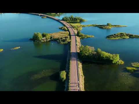 Lemland in three films: a municipal portrait, a walking trail and the canal
 RailiLaali Sergejeff’s short entry is a first-person walk with dogs on Lemlandsleden around Knutsboda. The description is also in Finnish and locates the walk in Lemland, Åland. It gives the trail a human scale that a route map cannot: a visitor can picture a quiet walk rather than a demanding long-distance trek. The footage dates from 2012, so check the current trail map and conditions before following it.
 Perttu Hörkkö’s sailing clip records S/Y Lee passing through Lemströms canal on a journey from Korppoo toward Mariehamn. The description notes the 18:00 bridge opening and a further wait before the yacht reached harbour, making it a useful firsthand glimpse of how canal openings shape a day on the water. It is a record of July 2012, not a current timetable; bridge arrangements were later renovated and must be checked with the municipality.