A rural landscape on Åland’s westbound road
Hammarland is a municipality on Åland’s main island, west of Mariehamn and on the road toward Eckerö. It is not a single resort strip: villages, farms, wooded ridges and bays are spread across a landscape shaped by the sea and by the road that crosses it. ÅSUB recorded 1,644 residents in the whole municipality on 31 December 2025. That is the municipal population, not the number in Kattby alone, where the municipal offices and S:ta Catharina church stand.
The local character comes from the combination of an inhabited countryside and a route through it. Hammarland is close enough to Mariehamn for many residents to commute, yet its side roads lead to village museums, hiking trails and islands that require a boat. Explore in sections: the church and Kattby, the fields and forest around Sadelinleden, then the northwestern shore and Sälskär lighthouse. A walk or seasonal boat trip can take longer than the map suggests, so plan around current transport and opening information.
A church beside an older route
S:ta Catharina, Hammarland’s medieval stone church, stands beside an old postal road and the Iron Age grave field known as Kjusan. Visit Åland dates the nave to the second half of the 13th century and the vaults to the 14th; the tower’s position to the south is unusual. Inside, medieval decorative painting and brick-pattern imitation survive. The church is more than an architectural stop: it marks a long-lived meeting place in a parish landscape where burial grounds, roads and worship overlap.
The municipality says the old postal route may be identical to a medieval pilgrimage road from Finland farther west. That is a possibility, not a settled fact. The distinction matters: Hammarland’s past is visible in its buildings and routes, while some interpretations remain uncertain. The church and nearby graves provide historical anchors without an invented founding legend.
Sadelinleden recalls P. U. F. Sadelin, the 19th-century parish priest associated with establishing Åland’s first library in Hammarland. A local legend says every clock in the vicarage stopped when he died. The municipality preserves it as a story, not as documented history. The trail gives that memory a wider setting: villages, church heritage and changing countryside rather than a monument to one person.
Walk through villages and working countryside
Sadelinleden runs for about 77 kilometres across Hammarland and neighbouring Finström, with roughly 43 kilometres in Hammarland. The municipality says the route is being developed gradually, so check the current map, markings and accessible sections before setting out. It can be walked in shorter stages. Lookout towers open views across woodland and the Åland Sea; the terrain shifts between meadows, forest, rocky ground and shore.
The route also links cultural and natural stops. At Vårdberg in Sålis, remains of a Russian coastal battery built during the First World War recall the islands’ strategic position; the fortification was demolished after the war, though traces remain. In Skarpnåtö, the homestead museum occupies a farmstead from the early 18th century. Its main building displays household objects, with local books and handicrafts giving a domestic view of island life. Parts of Stormskärs Maja and Iris were filmed nearby, but the museum’s value does not depend on screen recognition: it is a preserved rural setting rooted in the place.
Further inland, municipal trail information identifies Västanträsk as an apple-growing centre and Höckböle as a nature reserve with species-rich wooded meadows and orchids. These landscapes change with the seasons. Follow local guidance, stay on marked paths and avoid disturbing sensitive habitats. For a shorter outing, the church, village roads and one section of the trail can make a day without attempting the full route.
Beyond the mainland: Sälskär and the sea
Hammarland’s most remote landmark is Sälskär lighthouse, on an island northwest of the main island. The municipality says the brick tower was built and first lit in 1868; it gives its height as 39 metres and counts 164 steps to the lantern. The lighthouse reflects the demands of navigation in exposed waters and the former seal-hunting grounds that gave Sälskär its name. It is reached by boat, not road. Seasonal guided trips leave from Skarpnåtö and depend on the weather; check the operator’s current season, booking conditions and departure point.
The Åland Fire Brigade Museum in Mörby offers another view of local history. Its collection includes around 20 fire engines and equipment from across Åland, from an A-Ford dating to 1926 to a Volvo from 1969. It places everyday emergency work beside the better-known maritime and church heritage. Visitor arrangements can vary, so check before making a special trip.
Hammarland’s public services are centred in its villages rather than assembled for visitors in one resort. The municipality lists a library, school and family and social services; Kattby is the practical place to orient yourself and ask about local facilities. Shops and food options are more limited than in Mariehamn, and rural attractions may open seasonally or by arrangement. A car or bicycle gives the most flexibility for connecting the church, trailheads and Skarpnåtö; boat trips add access to Sälskär and the outer shore.
Seasonal traditions and local life
Midsummer remains a visible part of the calendar. The municipality records three large traditional Midsummer poles in Kattby, Torp and Bovik, alongside smaller poles elsewhere. This is a village custom spread across the municipality, not an attraction staged at one visitor site. If travelling in June, check local announcements for celebrations and dates.
Economically, Hammarland is closely connected to Mariehamn: the municipality notes that many residents commute to the capital. Agriculture and small rural businesses shape the countryside, and the municipal trail guide singles out apple growing around Västanträsk. The evidence supports those features, but not a precise ranking of jobs by sector. Visitors can see how homes, fields and service roads fit together, rather than infer employment statistics from the landscape.
Getting there from Mariehamn and Eckerö
From Mariehamn, follow main road 1 west through Jomala and Hammarland toward Eckerö. Kattby and the church lie along this corridor; turns to Skarpnåtö and other villages lead onto smaller local roads. The same route links Hammarland with Berghamn, Eckerö’s ferry terminal for services to Grisslehamn in Sweden. From Sweden, check the ferry crossing first and continue east by road; from Mariehamn, travel west. Ålandstrafiken lists rural buses on the Mariehamn–Hammarland–Eckerö corridor, but stops, service days and connections can change. Confirm the current timetable and return journey before relying on public transport.
A first visit can pair S:ta Catharina with a short village walk. A longer day can follow one section of Sadelinleden and include Skarpnåtö’s farmstead museum. Sälskär is a separate boat excursion, best planned around seasonal departures and weather rather than added casually to a road itinerary. Hammarland’s appeal lies in moving between settings: an old church and postal road at the centre, working villages inland, and a lighthouse where the road finally gives way to open water.
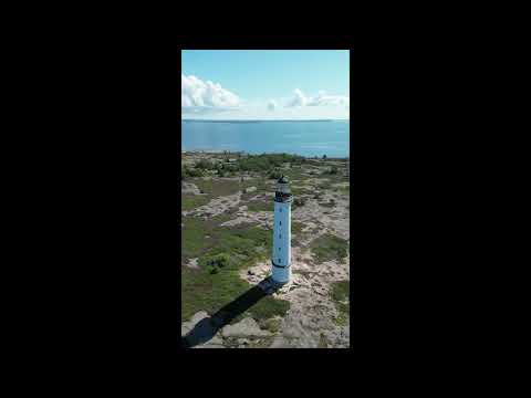 Hammarland in three films: Sälskär lighthouse, Skarpnåtö and Midsummer
 Mattias Andersson’s “Skarpnåtö-Äppelö” brings two neighbouring island names together. That makes it a useful prompt to look beyond one village and consider the coastal geography around Hammarland and nearby Geta. The title alone does not establish a walking or sailing route, so treat the film as a personal visual impression rather than navigation advice. Check local information before planning a crossing or a visit to Skarpnåtö’s homestead museum.
 The Hagelin channel’s film is explicitly about a Midsummer pole in Hammarland. It provides a seasonal counterpoint to the lighthouse and island landscape: village customs are also part of what makes a rural visit distinctive. The municipality describes major poles in Kattby, Torp and Bovik, but this film’s title does not identify which celebration it records. Use it as a glimpse of the tradition, then check local announcements for dates and public events.