
At the river mouth, with the sea close by
Göteborg is best read through its water. The Göta älv carries the city toward the Kattegat, while old channels, quays and bridges draw the river into daily urban life. A short tram ride can move from a dense centre to the ferry terminal; farther west, the built-up city gives way to granite shore and island settlements. That shifting scale—working port, walkable neighbourhoods and open archipelago—is part of the place’s character.
Statistics Sweden counted 674,529 residents in the SCB-defined built-up locality (tätort) Göteborg on 31 December 2023. This is the continuous urban settlement used for the statistic, not the separate municipality of Göteborg and not the wider metropolitan region. Those boundaries describe different populations, so the figure is meaningful only with its stated scope.
A documented sequence, and a later legend
There was no single, uninterrupted “old town” at the river mouth. Lödöse, farther upriver, was an important medieval predecessor. Nya Lödöse was established in the fifteenth century near today’s Gamlestaden, and an earlier settlement named Göteborg was founded on Hisingen under Charles IX: it received temporary privileges in 1603 and formal ones in 1607. Danish forces destroyed that town during the 1611 war. The present city’s privileges date to 1621, when a fortified settlement was laid out beside the river entrance.
The familiar story that Gustav II Adolf pointed to the site and declared, “Here the city shall stand,” belongs in a different category. Göteborg’s own municipal history calls it a myth; it is a memorable later explanation, not a documented quotation. The surviving canals, the planned inner grid and the hilltop defences tell a firmer story: this was a strategic border port built to protect trade and Sweden’s western access.
Trade, workshops and a changing waterfront
Shipping and commerce shaped the city from its beginning. In the eighteenth century, herring fisheries and the Swedish East India Company tied Göteborg to long-distance markets. Nineteenth-century mechanical workshops and shipyards then made the riverfront a place of heavy industry. The twentieth-century shipyard crisis brought that dominance to an end; old industrial areas on the northern bank have since been adapted for new districts, work, housing and education.
The port remains an active economic presence rather than a backdrop. Its 2024 figures include 909,000 handled containers and more than 500,000 container units moving to or from the port by rail. Across the wider Göteborg region, automotive and mobility firms, logistics, technology, research and life sciences sit alongside the maritime economy. Regional industry figures should not be mistaken for city-only employment totals, but they help explain why the town feels both outward-looking and technically minded.
Reading the city on foot
Start by the Stora Hamnkanalen and Gustaf Adolfs torg, where the old administrative centre meets the water. Nearby Kronhuset, built between 1642 and 1654, is among the city’s oldest surviving buildings; the adjoining park offers a quiet pause amid streets once planned as part of a fortress town. Haga gives a different scale: timber houses, cobbled lanes and the distinctive landshövdingehus—stone ground floors beneath two wooden storeys—recall nineteenth-century housing. Climbing to Skansen Kronan brings the roofscape, tram lines and river corridor into one view.
To connect history with the present, continue from the centre toward the riverfront and Lindholmen. The former shipbuilding landscape is still legible in its broad quays and industrial structures, even where buildings now serve different purposes. Gamlestaden, meanwhile, is the place to look for the earlier Nya Lödöse story. These are urban walks rather than a single marked heritage circuit; allow time for crossings and check current access where construction is under way.
From tram to island ferry
Göteborg’s visitor services and public transport make short, contrasting excursions practical. The official city guide describes tram 11 from central Göteborg to Saltholmen, where boats serve the car-free southern archipelago, including Styrsö and the farther-south islands. The islands reward walking more than hurried sightseeing: paths, rocky swimming places and small harbours are part of the experience. A bridge links Styrsö and Donsö for travel on foot or by bicycle.
Schedules, connections, fares and seasonal services can change, and ferries may be busy in good weather. Check Västtrafik’s journey planner before leaving, allow time for the tram-to-boat connection, and confirm opening hours and access for any indoor attraction on the day. In Göteborg, the useful itinerary is often a simple one: follow the river’s history in the morning, then let the tide set the pace for the afternoon.
 Gothenburg on film: historic centre, archipelago and Haga walk
 Visit Öckerö’s 57-second destination film introduces the archipelago west of Göteborg. Its description names hiking and walking paths, nature reserves, islands and outdoor activities, so it works as a quick visual prompt for a ferry-day decision rather than a route or timetable. Check current services and conditions separately.
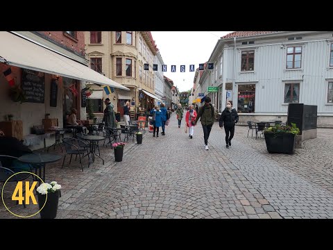 Planet Sweden’s longer Haga-and-Järntorget walk offers a street-level view of the neighbourhood. The uploader highlights timber buildings, cobbled lanes and café life; it complements the fortress-city story with a view of how a later residential district feels on foot. The video is not a substitute for current access or opening information.