A village beside a lake that did not always exist
Castel di Tora stands on the northeastern shore of Lake Turano, in the hills of the Sabina region in Lazio. The water is striking, but it is a twentieth-century landscape: a dam built in the 1930s transformed the valley below the village. The settlement itself rises above the reservoir in a compact weave of stone houses, narrow lanes and steps. From the shoreline, the old center and the wooded slopes make a single view; on foot, the steep lanes bring the scale of a small mountain community back into focus.
ISTAT counted 271 residents in the whole municipality on 31 December 2025. That is the population of the comune, not just the historic center. A visit can include the village, the lake edge and a guided excursion to Monte Antuni, but these are separate experiences: the last requires prior arrangements with the municipality.
From Castrum Vetus to Castel di Tora
The municipality dates the village’s origins to the early medieval period of incastellamento, when fortified settlements spread across the countryside. Its first cited documentary mention is from 1035, under the name Castrum Vetus de Ophiano, in the Farfa chronicle. The place was called Castelvecchio for centuries. In 1864 it became Castel di Tora, a name the Comune says recalls an ancient Sabine-Roman settlement called Thora or Thiora. That is a memory preserved in the name, not proof that the present town was founded in Roman times. Roman-period traces are reported in the wider territory, while the visible settlement fabric is chiefly medieval.
The abbey of Farfa received the territory in 1092, and local ownership later passed among several families. The position of Castel di Tora and nearby Antuni helped guard the valley; the municipal account interprets their location and watchtowers as defensive. It also records a visit by Corradino di Svevia in 1268 after his defeat at the Piani Palentini. These dated references give the town a documented medieval history without needing to turn local legend into fact.
The reservoir, its cost and a changing livelihood
Construction of the Posticciola dam began in 1936 and ended in 1938. The Comune explains that the reservoir was created to produce electricity and regulate the Turano River, reducing floods in the Rieti plain. It also submerged fertile valley land and displaced the agricultural balance: the municipality records emigration and a strong population decline after the dam. The lake is therefore not just scenery. Its broad surface belongs to a history of infrastructure, lost farmland and changed work.
The same municipal history describes a gradual shift from agriculture and pastoralism toward commerce, tourism and other services. Today visitors encounter the lake through outdoor activities and hospitality, but availability varies by season. The Comune’s accommodation and restaurant directory was last updated in 2021, so contact providers directly rather than assuming every listing or service remains current. The local economy is best understood as a transition, not as a single tourism story that erased earlier work.
Monte Antuni: a second settlement above the water
Across the reservoir, the peninsula of Monte Antuni points back toward Castel di Tora. The small settlement has its own history of lords and landowners, but the decisive rupture came in 1944, when it was bombed; the Comune says the last inhabitants had left by 1950. Restoration began in 1996, and the Palazzo del Drago and nearby houses were recovered. The result is neither an untouched ruin nor a continuously inhabited medieval quarter: it is a restored heritage site whose emptiness and reconstruction are part of the story.
Access is controlled. The municipal page says Monte Antuni and the castle can be visited only with a guide booked through the Comune. Check current dates and arrangements before crossing the isthmus; the page was last revised in 2020. The old center of Castel di Tora itself is a more immediate walk: stone façades, flights of steps, tight turns and sudden openings toward the lake provide the main experience. Wear shoes suited to uneven, sloping streets.
Lake, paths and nearby stops
The municipal lake guide describes options that include canoeing, fishing, walking, cycling and swimming. Conditions and services depend on the season, water access and local operators, so confirm what is open rather than assuming a beach or rental is available on arrival. Nearby Colle di Tora and Posticciola help explain how settlements, the dam and the reservoir fit together. The surrounding Monte Navegna and Monte Cervia protected area adds wooded trails and higher viewpoints.
A new Cammino del Lago del Turano is presented as a 100-kilometre loop in six stages, with a shorter 50-kilometre version in three. The regional tourism authority warns that the route is still being verified and optimized and that the full trail lacks dedicated signage. Use the current GPX track and check the latest trail condition before setting out; do not rely on signs that may not exist yet.
Getting there and planning a stay
By car from Rome, an older local visitor guide describes the SS4 Salaria toward Osteria Nuova, then the route through Poggio Moiano and onto the SP Turanense. From Carsoli, the Turanense also leads toward the lake. Check a current map and road notices before departure, especially in poor weather. Cotral serves the valley, including a Castel di Tora–Rieti connection, but services are limited and stop arrangements can change. Search Cotral for the exact day, confirm the return trip before leaving Rieti or Carsoli, and allow for a slower journey than the map suggests.
Castel di Tora is best planned as a landscape visit rather than a checklist of open monuments. Give time to the stone center, the lake’s engineered history and, with a booked guide, Monte Antuni. Add neighboring villages or a measured walk only after checking transport, water activities and the trail status. That approach lets the place’s beauty and its more difficult history remain visible together.
 Castel di Tora in video: il borgo, il lago e la Valle del Turano
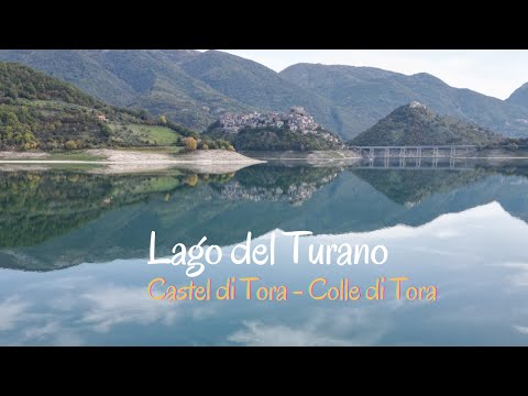 In just over ten minutes, this vlog follows the wider Turano Lake area, including Castel di Tora, Monte Antuni, the dam, a panoramic viewpoint and Colle di Tora. It helps place the village in a larger day route rather than treating it as an isolated stop. Use official sources for the historical details and confirm current access before travelling.
 This 14-minute documentary-style report looks at the Turano Valley as a whole: the reservoir’s creation, submerged farmland, hillside villages and present-day outdoor tourism. Its subject is the social and landscape transformation of the basin, giving context beyond a scenic walk-through. It was published in June 2026 and should be read as a regional report, not as a live service update.