Casale Marittimo looks out from a hill over the Cecina valley, with the Tyrrhenian coast about 12 kilometres away. The view draws the eye toward the sea, but the town’s strongest story is layered underfoot: an Etruscan settlement and cemetery lie in the wider territory, Roman villas left remains nearby, and the compact stone centre grew into a medieval hill town. The 2026 Italian resident-population estimate counts 1,047 people in the whole municipality on 1 January. That is a municipal figure, not a count of visitors or of the old centre alone.
+Archaeology around the hill, medieval life in the centre
+Casale Marittimo’s municipal history places an Etruscan village on the nearby hill of Casalvecchio in the seventh century BCE and records another settlement there in the fourth century BCE. At Casa Nocera, excavations revealed a cemetery associated with a powerful local family; the tombs and their finds belong chiefly to the seventh and sixth centuries BCE. A round tholos tomb at Poggiarelle was found by chance in 1896. These are substantial traces of Etruscan life in the territory, but they do not make the present medieval town a Roman foundation. The municipality also identifies Roman villas at La Pieve and Il Poggio, whose finds include materials later reused in local buildings. Cecina’s archaeological museum preserves the burial assemblage from tomb A at Casa Nocera, making it a valuable companion to a walk in the area.
+A more recent origin story deserves the same care as the ancient evidence. In the eighteenth century, the scholar Giovanni Targioni Tozzetti reported a local tradition of two castles, Casalvecchio and Casalnuovo, the latter identified with the present town. Archaeological work has not confirmed that pair of castles. It remains a piece of community memory, not an established reconstruction.
+The hilltop centre itself invites close looking. Its lanes follow semicircular rings of medieval walls; the outer walls often became the backs of houses, so domestic stonework and fortification share the same fabric. A ramp rises toward the part residents still call “the Castle.” The clock tower, built in 1854 where a gate once stood, marks the entrance. In the town’s account, the parish church of Sant’Andrea was first mentioned in 1305; the old building later served as a school and then as the town hall. The present Sant’Andrea was built in 1872–74. Nearby, Santa Maria delle Grazie dates to 1712–16, while the smaller San Sebastiano was built in 1775. Look for the Roman stone fragments and carved pieces reused in later structures: they make the town a visible palimpsest rather than a sequence of sealed historical periods.
+A working landscape with paths to follow
+For centuries the local economy centred on agriculture. The municipality’s history says the twentieth-century population fell to 837 in 1971, then began to recover as some residents returned and international visitors arrived. Its 2024 account describes tourism as the leading source of income, while noting the renewed cultivation of cereals, olive oil and wine. The town’s current visitor pages list local producers, accommodation and places to eat. These are not competing identities: vineyards and olive groves shape the countryside that visitors come to see, and rural products remain part of its economy. The Etruscan Coast Wine Road also crosses the area. Ask farms directly about visits and tastings, since access is not automatic.
+The municipal walking page describes three marked routes. The yellow itinerary runs 10.5 kilometres south from the village, passes the La Pieve area and its Roman villa site, and continues toward the Magona scrubland. The green route is a shorter three-kilometre walk toward the archaeological zone of Casalvecchio. The orange route, 3.5 kilometres, crosses olive groves and vineyards before reaching the Linaglia dam in Mediterranean woodland. Hills and uneven rural surfaces make these real walks rather than flat promenades; check the town’s current map and path conditions before setting out. Around the centre, the Pro Loco room has photographs and plans from archaeological work, though access depends on local opening arrangements.
+Regional tourism information notes the summer Sagra delle chiocciole and Sagra del cinghiale as food events, traditionally held in July and August. They offer a way to meet the town beyond its viewpoints, but programmes and dates vary each year. Confirm the current municipal calendar rather than travelling on the assumption that a past date will repeat.
+How to arrive and extend the visit
+The municipal directions identify Cecina as the nearest railway connection on the Pisa–Grosseto line, followed by a local bus. Autolinee Toscane’s route 110 connects Cecina with Casale Marittimo and continues through Bibbona and nearby villages. The operator’s live page lists several stops in Casale and publishes service notices, which can change routes or timetables; check the date and direction before boarding. By car, the municipality directs drivers from the SS1 Aurelia to the Cecina/La California exit, then along the SP39 and SP28 to the village. The same roads link the hill town to the coast, around 12 kilometres away. Cecina makes a useful second stop: its municipal archaeological museum displays the Casa Nocera grave goods, while the local coastline offers a different landscape from Casale’s wooded, cultivated hills.
+Give the village time on foot before heading downhill. The best visit combines the walls and churches with a longer look at the Etruscan landscape, a farm visit arranged in advance, or the museum in Cecina. It is this close relationship between a living hill town, deep archaeological evidence and an active agricultural countryside that gives Casale Marittimo more to offer than a quick photo stop.
+ Casale Marittimo on video: a hill-town walk, a short portrait and a public-space project
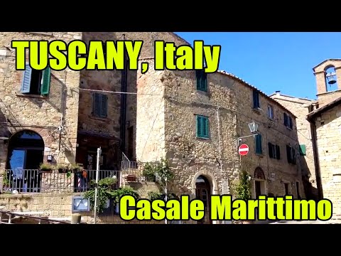 Cinematic Travels’ short 2023 portrait presents Casale as one stop among Tuscany’s historic towns. It gives a compact visual introduction to the built fabric and the way the old village sits above the coastal landscape, so it can help a first-time visitor decide whether to linger. The description is promotional and provides little documentation: it is not an archaeological source, a detailed route or a current guide to transport and opening times. Its best role is as a quick overview, followed by the municipal account of the circular walls and the regional information on the Etruscan sites.
 The Tuscany Region’s Sviluppo Rurale film belongs to its documented series on rural-development projects, not to a general tourism channel. The associated project record identifies the subject as the 2012–13 renewal of Coppaio, a panoramic public space below the village, and describes new stone paving and restored steps. That makes the video valuable for understanding how public works shaped the visitor’s route and residents’ shared spaces. It is an institutional account of a completed project, so its figures and aspirations describe that investment period rather than current services or the present state of every path.