Pyhäntä is a broad, lightly settled municipality in southern Northern Ostrobothnia, where two regional roads meet beside the lake that gave the centre its name. The western side opens into low Ostrobothnian country; farther east, forested ridges, small lakes and wetlands make the ground more varied. The municipality covers 846.75 square kilometres, including 36.55 square kilometres of water. Statistics Finland’s figure cited by the municipality records 1,678 residents across the whole municipality on 31 December 2025. That number includes the villages and scattered countryside, not only the small kirkonkylä on Pyhännänjärvi. For a visitor, the distinction matters: this is a destination to explore by car, with individual walks and heritage stops spread among the centre, Ahokylä, Tavastkenkä and the shores of Iso-Lamujärvi.
A lake landscape with a long human record
Water shapes both the view and the route through Pyhäntä. The municipality lies on a watershed from which the Siikajoki begins. Pyhännänjärvi sits directly beside the centre, while Iso-Lamujärvi is known locally for its sandy shores, islands, boating and summer cottages. East of the centre, esker country and clear-water ponds replace the flatter western fields. A drive between these places feels less like moving between formal attractions than following a chain of lakes, forest roads and villages; leave time for short stops rather than planning a single compact town-centre walk.
The archaeological record reaches much farther back than the written history of the municipality. Municipal history and a local archaeological inventory describe Stone Age dwelling sites and tool finds around Tavastkenkä, with some evidence associated with the ancient shoreline more than 7,000 years ago. The municipality also lists the Lohipuro reindeer-hunting pits and boat remains in the bed of Hautalampi, although its visitor information does not date these finds. They are evidence of different ways people have used the landscape, not proof of a single ancient town or a legendary founding event. Pyhännä’s written village history begins in 1557, when a record names three households by Pyhännänjärvi. Tavastkenkä appears in tax records from the 1560s and in a 1573 list. The name Tavastkenkä has competing scholarly explanations, including one based on old Swedish and a possible Sámi-language origin; neither should be presented as certain.
From parish village to industrial municipality
For centuries the area’s villages grew around farms, waterways and local meeting places. In the nineteenth century, dairy cooperatives and butter sales became part of the rural economy; forests later supported logging and timber transport. The municipality and parish separated from Piippola and became independent in 1909. The church by Pyhännänjärvi had been completed in 1907–1909 to a design by provincial architect W. A. Tötterström. Its National Romantic form and Kaarlo Metsävainio’s altarpiece, “The Good Shepherd,” give the lakeside centre a clear landmark. The church is an active parish space, so visitors should confirm access and service times with the parish rather than assume it is open as a museum.
Pyhäntä’s modern profile is unusually industrial for a rural municipality. The municipal facts page reports that processing accounted for 60.4% of jobs in 2023, compared with 13.9% in primary production and 24.8% in services; workplace self-sufficiency was 134.9% that year. The municipality identifies industry as its largest employer. Those dated figures help explain why the centre developed around a road junction and why working yards and production sites sit close to lakes and forest. They also add a useful layer to a visit: Pyhäntä is not a preserved open-air tableau, but a living municipality whose jobs, services and rural surroundings have grown together.
Museum buildings and a writer’s summer place
Near the shore, the local-history museum gathers the material details of farm life into a small group of buildings. A dwelling house, granaries, smoke sauna, smithy, windmill, former communal-grain store and sheds were moved from different parts of the parish during the 1960s and 1980s. Inside are objects such as spinning tools, shears and household equipment. The museum began operating in 1964. It opens to the public at selected times in summer, with visits at other times arranged in advance; check the municipality’s current notice before making it the centrepiece of a trip.
A more personal literary stop lies on Iso-Lamujärvi. Korpelainen, Pentti Haanpää’s summer cottage, has been restored in a 1950s style. The Finnish writer spent summers there writing and fishing, and the municipality says visits are by agreement. The cultural route Pentin polut brings together places connected with his life and work in Pyhäntä and neighbouring Siikalatva, ending at Korpelainen. It offers a way to connect the lake setting with the writer’s biography, but visitors should confirm which sites are open and whether transport or a local event is required.
Trails, swimming and the villages
For a half-day outdoors, head to Iso-Ahvenjärvi in Ahokylä, about 24 kilometres from the centre. The municipal Kairanmaankierros trail is eight kilometres long and has three lean-tos with fire sites. It passes through the esker and lake setting of Hellämönharju, a Natura area; the lakeside facilities include a beach, grill shelter, hut, toilet, sauna and accommodation buildings. Fishing is possible only under the relevant permit rules. This is a rural trailhead rather than a staffed visitor centre, so check the route’s current condition, fire guidance and accommodation arrangements before setting out.
Other outings suit different paces. Iso-Lamujärvi has sandy beaches on both the west and east shores, a boat harbour on the Kamulankylä side and islands for a quiet boating day. At Pyhännänjärvi, a rest area by the bridge gives a broad view across the lake and the centre’s beach is close to everyday services. Salmijärvi offers boggy ponds and long views from the ridge road; Kontionkangas, roughly ten kilometres towards Kajaani, has esker paths and a lakeside cabin and sauna that can be rented. The municipality also identifies old forest areas at Itämäki–Eteläjoki and the bird habitat of Kansanneva–Muurainsuo. These sites are dispersed, and some facilities are privately managed, so a map and a quick call ahead are more useful than assuming every trail has the same level of service.
Getting there and staying overnight
National highway 28, between Kokkola and Kajaani, crosses regional highway 88, between Iisalmi and Raahe, in the centre. The municipality gives distances of 122 kilometres to Oulu and 77 kilometres each to Kajaani and Iisalmi. Those figures make Pyhäntä a practical stop between larger regional centres, but the spread of villages and lakes means a car is helpful for reaching the trailheads. The municipality says direct buses arrive from several directions throughout the year and that long-distance Oulu–Kuopio coaches stop at the business centre. Connections via Ylivieska link to Helsinki–Oulu trains, while services through Kärsämäki connect with long-distance buses. Service days and school-holiday timetables change; check the live timetable for the exact date and allow time for onward travel.
Accommodation is modest and concentrated around the centre and outdoor areas. The municipal visitor page lists a seven-room hotel at the road junction, with fuel service and electric-vehicle charging nearby, as well as a small apartment hotel by the lake. Cabins and simple lodging are also available at selected recreation areas, but these are arranged by their operators and may be seasonal. Shops, library and other everyday services are in the centre; for meals, room availability and opening hours, confirm directly before travelling. A good first visit pairs the lakeside church and museum with one longer outing—Kairanmaankierros or Iso-Lamujärvi—then leaves another day for Korpelainen and the rural villages.
 Pyhäntä on video: church, lake and aerial views
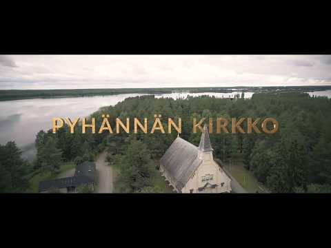 The parish’s short introduction, ‘Pyhännän kirkko’, focuses on the lakeside church and is a compact way to prepare for a visit. The municipality dates the National Romantic building to 1907–1909 and identifies its architect and altarpiece; the video provides a church-centred complement to those written details. At just under three minutes, it works as a brief orientation, not as a substitute for checking whether the church is open. The building remains an active parish space, so access may depend on services and local arrangements.
 Henkkaa’s seven-minute recording is identified in its title and description as a dive at Iso-Ahvenjärvi in Ahokylä, with coordinates supplied on the public video page. This is a distinctly local perspective on a lake that the municipality also presents as a swimming, hiking and fishing area. The listing establishes the subject and place, but does not provide a dependable guide to current water conditions, access or fishing rules. Visitors can pair the video with the municipal trail information and check permits and facilities before travelling to the shore.