A working town on the Nissan
Gislaved is the municipal centre of western Småland, but its identity is more specific than the familiar tyre name suggests. The town grew beside the Nissan, where waterpower, a road crossing and later the railway drew work and trade together. Its centre still feels practical and lived-in: shops and public services sit close to the river, and industrial buildings tell a story that has not been polished into a period set.
Population figures depend on the boundary being described. Statistics Sweden counted 10,029 people in the statistically defined Gislaved locality, or tätort, on 31 December 2023; the mapped built-up area covered 707 hectares. This is not a 2026 estimate and not the population of Gislaveds municipality. The municipality-wide number is much larger because it includes countryside and several other settlements.
What the records establish—and what remains a proposal
The municipal history records the name Gislaved in 1434, when it referred to a mill. It also places the founding of Gyllenfors ironworks beside the Nissan in 1743. A settlement then spread on both banks around the works. A permanent village shop arrived in the mid-nineteenth century; Gyllenfors glassworks followed and operated from 1850 to 1903. The railway reached the village in 1901, and rubber manufacturing helped turn the growing industrial community into the main town it is today. Gislaved became a market town in 1949.
There are earlier traces, but they should not be made into a confident foundation story. The municipality says archaeological indications suggest prehistoric occupation, while noting that it has not been established. It also gives “Gisle’s forest” as a possible explanation of the place-name, not a proven translation; Gisle was a common male name. The 1434 mill reference and the dated industrial milestones are firmer documentary points than either hypothesis.
Industry, water and the townscape
Gislaved’s manufacturing legacy includes rubber, leather, glass and plastics. The municipal industrial-history account describes plastics, rubber and leather working as defining branches of twentieth-century production; the local museum keeps objects and machinery from those industries together with material from the former glassworks and ironworks. The wider municipality remains strongly oriented toward manufacturing, including plastics and metalworking, alongside trade, services, forestry and farming. That combination helps explain why Gislaved is both a service centre and an industrial town rather than a resort settlement.
The museum occupies the old Remfabriken, dated by the municipality to 1893, beside a waterfall on the Nissan. Its collections give visitors a tangible route through work and domestic life: early rubber balls, galoshes and tyres, glassware, plastics and leather drive belts. Outside, the river is not just scenery. Nissan’s shifting bends and sandbanks shaped the valley, and waterpower helped several settlements in the municipality develop industry. A municipal nature-and-culture path follows the river through Gislaved, joining waterside views to the town’s industrial landscape.
For a different period of local design, look at the municipal building completed in 1973. Designed by Voldemars Vasilis, it is a conspicuous example of post-war modernism and concrete Brutalism, with an airy central hall and an accompanying park in the architect’s plan. It is an administrative workplace, so treat it as an exterior townscape stop unless public access is announced.
Everyday facilities and nearby outings
As the municipality’s principal settlement, Gislaved has a broad town-centre offer, grocery shopping, schools and leisure facilities. Gislebadet has a 50-metre pool and a teaching pool; the central library and local cultural programme add indoor options when the weather turns. Enter Gislaved provides visitor information for the wider region. Check current opening times rather than relying on older listings, especially for the museum, pool and seasonal events.
For a longer excursion, Anderstorp and its Scandinavian Raceway lie elsewhere in the same municipality; the museum’s own film page connects the local industrial story with a short documentary trailer about the site. The Isaberg outdoor area near Hestra is another regional outing, with marked walking routes and seasonal activities. These are separate destinations, not extensions of a walk from Gislaved’s centre. Check access, conditions and event calendars before setting out.
Road and bus connections
Gislaved stands where national road 26, the Nissastigen route between Halmstad and Jönköping, meets road 27. The municipality describes the town as a bus interchange; there is no railway station in Gislaved itself. For onward journeys, use Jönköpings Länstrafik’s current planner and check disruptions, connection times and service days before travel. Route numbers and timetables can change.
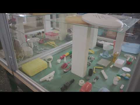 Three Gislaved films: the industrial museum, Västbo and Anderstorp raceway
 This 6:01 film widens the lens from one building to industrial museums across Västbo. The Swedish description explicitly joins Gislaved and Gnosjö in a shared industrial history and says viewers will get a preview of museums they can visit. That regional frame helps explain how the story of Gislaved belongs to a larger network of workshops and manufacturing settlements. The video was published 5 October 2021; treat it as context, not a current visitor timetable.
 The museum film page presents this 1:30 upload as a trailer for the documentary “Mossen som blev en Motorbana” (“The bog that became a race circuit”), with the full film available to see at the museum. Its description announces a 2023 screening at Biograf Folkan in Gislaved and names the filmmakers. The subject is Scandinavian Raceway in neighboring Anderstorp, a regional excursion rather than a sight in the centre of Gislaved. The trailer was published 25 May 2023.