A small town with a wide horizon
Fouras occupies a narrow peninsula where the Charente reaches the Atlantic. Its scale is modest, but its outlook is not: from the shore the eye moves across the estuary toward Île d’Aix, Oléron and Ré, while Fort Boyard sits offshore as a landmark in the Pertuis d’Antioche. The town’s coastal identity is not only a summer image. Fishing, shellfish cultivation, local shops and public services belong to an inhabited commune whose rhythm changes with the season and the tide.
INSEE counts 4,148 municipal residents across the whole commune in 2023; that reference population took effect on 1 January 2026. The same statistical system records 933 jobs located in Fouras in 2023. These are annual commune-wide measures, not a count of summer visitors. They help place the resort in context: Fouras is a small working town whose visitor economy sits beside everyday services and maritime trades.
Fortifications at the mouth of the Charente
Fouras’s position made control of the estuary valuable. Fortifications around the mouth of the Charente formed part of the defensive system protecting the approaches to Rochefort and its naval arsenal. The keep of Fort Vauban now houses the Fouras museum, where local and regional collections give the stone structure a civic role beyond its military past. From the waterfront, the fort is also a practical landmark: it stands above the town and frames views back across the beaches and islands.
The defensive landscape continues toward Fort Enet, built in 1810–1812 on the seaward end of the peninsula. It is not a casual walk at any hour: the causeway is exposed by the tide, and visits take place only on published guided dates. Check the access calendar and tide information before setting out. Fort Boyard, familiar from the sea, is not open for visitors to land on; boat excursions offer the way to see it at closer range.
Beach life and a working shore
The peninsula has five beaches spread over roughly four kilometres and three ports. The islands shelter much of the coast from the strongest Atlantic swell, giving the shoreline several different aspects within a short walk: open sand, small coves, harbour edges and outlooks over the channels. At Pointe de la Fumée, the ferry pier and shellfish activity share the same tidal landscape. The municipal planning report documents oyster and mussel cultivation here, including oyster-spat capture. That work is a reminder that the water is a productive environment as well as a view.
In the centre, the covered market and fish hall connect a visitor’s day to the town’s everyday life. The seafront has cafés, restaurants and shops, while the museum offers a way to understand the forts and the history of the bathing resort. Low tide can reveal places for shore fishing, but the returning water can cut off a route quickly. Follow local safety instructions, avoid oyster plots and never treat an exposed passage as a fixed land path.
Getting there and using Fouras as a base
R’Bus line E links Fouras with Rochefort via Saint-Laurent-de-la-Prée and Le Vergeroux. The nearby TER stop at Saint-Laurent-de-la-Prée provides rail connections; a seasonal regional bus line serves La Rochelle in July and August. From Pointe de la Fumée, the ferry to Île d’Aix takes about 20 minutes, making a day trip possible without a car on the island. The peninsula also lies on the Vélodyssée and Flow Vélo cycling routes. Confirm current bus and train departures, ferry sailings, museum opening periods and tidal access before planning a connection; seasonal timetables and sea conditions matter here.
 Fouras from above, then through its forts and seaside architecture
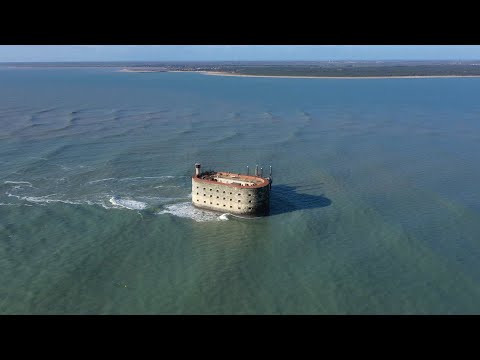 The Nouvelle-Aquitaine video guide places Fouras within the chain of forts at the Charente estuary, including Fort Vauban and Fort Enet. That wider frame helps explain why a seaside walk repeatedly meets military architecture. The film is a useful heritage preview; visitors should still check which sites are open and which require guided, tide-dependent access.
 France 3 Nouvelle-Aquitaine turns from the defensive coast to the resort’s domestic architecture through Villa La Jetée. This focused report gives a more intimate angle on how Fouras became a bathing destination, complementing the aerial landscape and the forts rather than repeating them. It is especially relevant to visitors interested in the town’s built heritage.