Bjurholm is not a preserved open-air village: it is a small, working service centre whose streets still make sense when read against the valley below them. It stands in southern Västerbotten, in northern Ångermanland, about 60 kilometres west of Umeå. Öreälven passes west of the built-up area, and the land rises sharply from its ravine to wooded, rolling ground. The municipal museum survey records a difference of roughly 100 metres from the riverbank to the flatter moraine above. This close contrast between settled roads, forest edge and deep river country gives the town its particular character.
Population needs a clear boundary. Statistics Sweden’s latest published locality table available for this profile gives 984 residents in the statistical Bjurholm tätort on 31 December 2023. That figure belongs to the mapped built-up locality, not to every village in Bjurholm Municipality. The municipality’s total is a separate, larger count; it should not be substituted for the town’s population. The same distinction matters throughout this sparsely settled region: Bjurholm’s shops, civic services and visitor facilities serve an extensive rural hinterland.
A documented beginning on the river route
The strongest local account is not a founding legend but a sequence reconstructed from maps, archival material and building evidence by Västerbottens Museum. It places the first crown-land settlement on the east side of Öreälven in the early 1750s, along the rowing route between Agnäs and Örträsk. A first winter dwelling was formally inspected in 1759 at Gammgården. The earliest households farmed modest plots, kept animals, cut hay from wet meadows and also hunted, fished and worked in the woods. Håknäs sawmill, established downstream in 1761, drew timber from the valley; spring floating linked forest work to the river.
The later chronology is equally tangible. A church and parsonage were completed in 1807 after growth in the district made the long journey to Nordmaling’s parish church difficult. Bjurholm became an independent parish in 1815. Roads were extended to the church place from Nordmaling in 1825, to Örträsk in 1856, Vännäs in 1863 and Fredrika in 1867. A guesthouse appeared by a road junction in 1869; shops, cafés, tradespeople and public functions followed the road corridor. The 1875 church burned and was replaced by the present church in 1935. Bjurholm’s municipalsamhälle was formed in 1934, and its first town plan followed in 1953. A separate municipal history explains that Bjurholm’s parish was detached from Nordmaling in 1808, later joined Vännäs in 1974, and became a municipality again on 1 January 1983. These are administrative milestones, not interchangeable dates for the town’s first settlement.
Balberget is described by the museum as a historic boundary point where old lines associated with Ångermanland, Lapland and Västerbotten met. That is a documented landscape interpretation, not a statement about present county borders. Local stories may add texture to a place, but the account above keeps archival chronology separate from legend rather than asking folklore to prove a date.
Everyday economy and practical services
Bjurholm’s role is easiest to understand as a centre for a much wider countryside. The municipality’s current business strategy says agriculture and forestry remain important long-standing sectors while the area works to diversify its business base. That is municipality-wide context, not a claim that every sector is concentrated inside the tätort. In the centre, retail, municipal services, school and community facilities make it a practical point of contact for residents from the surrounding villages. The town’s small scale means errands and a walk through the central streets can be combined without turning the day into a city itinerary.
Public transport exists, but the current municipal information is candid about its limits: local routes are chiefly designed around school journeys and run on school days. Route lists can change, and the municipality records that one line ended on 1 January 2026. Visitors arriving by bus should check the current timetable and return service before setting out. Bjurholm also has a municipal swimming hall with a main pool and a shallow children’s pool; exercise, family and public sessions are scheduled separately. The library belongs to the shared Umeå-region library system and has an extended-access option for registered borrowers. Opening arrangements, access rules and seasonal hours should be checked directly rather than assumed from a general town profile.
Architecture and small-town layers
There is no single monumental façade that explains Bjurholm. Its heritage is a sequence of modest buildings and routes: old farm sites, the church precinct, former parsonage land, school buildings and the roads that gradually connected the parish to neighbouring centres. The museum survey identifies a historic farm grouping recorded on the 1798 settlement map, a church site from 1807, the present church from 1935, and a school area that grew from the 1948 central school. It also describes the 1950s and 1960s housing as low detached houses with small gardens, a scale still legible in the town’s residential streets.
The church precinct is worth noticing as a living civic landscape rather than a staged monument. The present church replaced the burned 1875 building; nearby traces include former parsonage functions and the older routes toward Örträsk and Nordmaling. The municipal heritage programme also notes a local heritage-area building moved there in 1947. These details make a slow walk through the centre rewarding: look for how the old north–south road lines, public buildings and later residential blocks sit beside the ravine and newer road infrastructure.
River country beyond the centre
Walking is the most direct way to see why Bjurholm’s landscape matters. The municipal Öreälven trail page describes a roughly 50-kilometre section between Örträsk and Agnäs within Bjurholm Municipality. Its river valley alternates between deep-cut slopes, bends, rapids and quieter water; named stretches include Långforsen and Näslandsforsen, while the route toward Agnäs passes Lagnäset’s hay meadows. The larger trail continues south into Nordmaling. The municipality also lists shorter paths around the district, including Kärleksstigen in Bjurholm, without publishing a fixed distance for that local walk.
Trail length on a page is not a promise about present ground conditions. Spring and autumn floods can move the riverbank and force route adjustments; follow current signs, markings and local notices. Longer stages require planning for transport, weather and overnight stops. Nearer excursions include Balberget, a forested high point with broad views and a rest cabin, and Lagnäset’s river meadows when seasonal conditions allow. Neither is a substitute for checking access, parking and trail status before departure.
Visitors, food and a realistic day plan
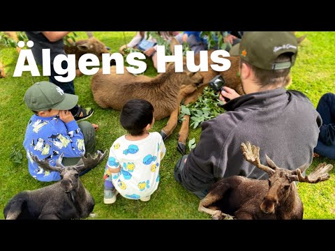
Älgens Hus, at Västernyliden outside the centre, is the best-known visitor attraction associated with Bjurholm. Its own current notice says visits are by booking only, with a minimum booking value equivalent to 20 people. The site describes guided visits, a museum and a chance to meet the animals; it does not promise walk-in admission. Contact the operator before building a day around it. In town, the swimming hall and library are useful facilities, while cafés and local shops provide the everyday scale of a county-side service centre. Specific business hours vary; verify them before travel.
By road, Bjurholm connects with the surrounding villages and the wider Umeå region; the municipal heritage and planning maps show the historic approaches toward Vännäs, Örträsk, Nordmaling and Fredrika. A thoughtful short visit can stay close to the centre: notice the church and old road pattern, have time for local services, then take a marked walk if conditions are suitable. A longer trip can pair a river-trail stage with a booked attraction, but transport between trailheads is not automatic. Check bus schedules, trail notices, opening times and seasonal access on the day you travel.