Aneby is a compact centre on the Småland highlands, where a working small town opens quickly into lakes, wooded paths and an older farmed landscape. Statistics Sweden counted 3,653 residents in the geographically defined Aneby urban locality (tätort) on 31 December 2023. That figure describes the mapped built-up area, not the population of Aneby Municipality. The distinction matters: the station, shops and civic services belong to the town, while several heritage stops lie in the surrounding countryside.
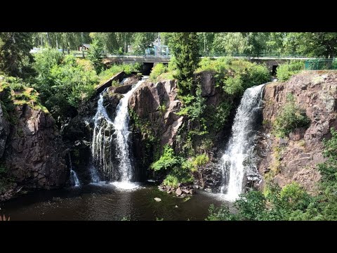
The landscape supplies Aneby’s most immediate landmark. Stalpet is a 20-metre waterfall on Svartån, which cuts through a rocky ravine below the fall and continues toward Lake Ralången. A municipal nature guide describes steps on both sides of the cascade and a café and craft shop beside it; another local page lists minigolf there. The experience varies with water flow and seasonal opening, so check conditions before travelling. The stream also ties the town to Anebysjön, a nearby southern lake with a short walking loop, bird tower, floating landing and wind shelter described by the municipality.
Aneby’s deeper past is visible in records and in the ground rather than in a single preserved historic street. At Aneby gård, south of the centre, archaeologists found traces of prehistoric ironworking during investigations in 1996: slag, furnace lining, pottery, whetstones, hearths and postholes. Nearby are a large Bronze Age cairn and Iron Age burial grounds. A Scandinavian-made gold medallion modelled on Roman imperial awards was found in a field in the 1930s. The county museum presents a link between iron production and the owner’s status as a possibility, not a proven explanation. Keep that interpretation separate from the excavated evidence.
Three kilometres southeast, Bredestadsdalen broadens the story. The county museum documents Bronze and Iron Age graves, a runestone, a Viking-era longhouse site at Bona and old routeways toward Eksjö and between Jönköping and Kalmar. Written sources place the district court at Bredestad in the 14th century; a local tale associates it with a now-vanished stone circle, but the museum distinguishes the legend from the documentary record. The valley’s fields, grazing land and wooded margins still show why routes and settlement gathered there.
The present-day economy is not simply a visitor economy. Aneby Municipality describes a diverse rural business base, with manufacturing, crafts and green industries as strong sectors and many small and medium-sized firms. Its employment page identifies makers and suppliers in healthcare products, playground equipment, packaging, metal finishing, containers and timber houses. This mix gives the town a practical, locally rooted character: everyday services and production sit alongside outdoor access rather than being replaced by tourism.
For a short visit, walk the Svartåleden, a roughly 7-kilometre town route along the stream, green areas and built-up streets; the municipality warns that one section is steep and uses stairs. The approximately 16-kilometre Målsånnaleden links town paths and forest tracks with Stalpet and the countryside. Longer walkers can use the 78-kilometre Anebyleden, part of Smålandsleden. A separate cycling circuit around Ralången is about 25 kilometres. Distances and surfaces differ, so consult the current route map and plan for weather, daylight and transport back.
Nearby excursions are spread across the municipality, not clustered in the centre. Åsens by is a cultural reserve presenting a Småland village setting around 1900; Bodaskog’s former shop and post office, Bälaryd’s rural museums and the Stierngranat museum and pyramid offer other local-history stops. Aneby railway station and regional buses make the town accessible, but connections and seasonal opening times change. Confirm today’s train or bus timetable, trail status, café hours and museum visits directly with the operator or host before setting out.