Walzbachtal is a municipality with two distinct village centres rather than one compact old town. Jöhlingen and Wössingen lie along the upper Walzbach on the western edge of the Kraichgau, with the agricultural hamlet of Binsheim attached to Jöhlingen. Their streets, churches and open slopes tell different chapters of a shared landscape. The S4 tram-train makes it possible to arrive without a car and then explore the villages and their walking paths at a slower pace.
The municipality’s own resident count for June 2026 is 10,018: 6,005 in Jöhlingen and 4,013 in Wössingen. That is a municipal register figure for the combined territory, not the count of a single village. The federal municipal register gives a separate total of 9,940 at 30 September 2026; the two official series differ, so they should not be read as a simple month-to-month population change. The modern municipality dates from 1 January 1971, when the formerly independent villages joined.
Two villages, a long record of settlement
Both names appear in a document dated 1024, when Salian ruler Conrad II transferred property in the area to the cathedral chapter of Speyer. That is the earliest written reference highlighted by the municipality, not a founding date. Archaeology points to much older human activity. Barrows on the Hohberg are associated with the Stone and Bronze Ages; a Celtic gold coin is a clue to Celtic presence, while Roman stone buildings and roads are documented especially in Wössingen. At Metzelsberg, a row-grave cemetery from the sixth and seventh centuries offers evidence of early medieval life. The evidence describes successive activity across the valley, not a single continuous settlement or a Roman foundation story.
The villages preserve different layers in their built fabric. Jöhlingen’s Speyerer Hof, a three-sided Franconian farmstead built in 1577, was restored by the municipality in the 1980s and now houses the public library. The Maria-Hilf Chapel, built in 1732 above Attental between woodland, remains a destination for pilgrimages, especially in May and the summer months. St Martin’s Catholic church was rebuilt in 1782–84. In Wössingen, the old timber-framed town hall dates to 1746; it is privately owned and listed. The Protestant church follows plans by architect Friedrich Weinbrenner, with its foundation stone laid in 1817 and consecration in 1822.
Jöhlingen’s Jewish cemetery, established in 1888, is another part of the local record. Forty-six gravestones remain, and the last burial took place in 1936. Its presence helps tell a fuller story of the community than the prominent church buildings alone. In Wössingen, the protected orchard meadows of the 12-Morgen reserve and the Wössingen Waldwiesen landscape preserve habitats beside the settlements. The Hungerquelle spring can emerge in surges after dry years and is a habitat for amphibians including newts and salamanders.
Walk between water, meadows and village landmarks
The municipality’s marked paths make the landscape accessible without turning a visit into a strenuous expedition. The “Wasser & Wiesen” loop is about 3.5 kilometres across mostly gentle ground, with information stations on the Walzbach, springs, wet meadows and orchard habitat. At the time of research, the municipality noted that construction work had closed the first section and supplied an alternative route; check that notice before setting off. Other options include the Frühmessweg between Jöhlingen and Wöschbach, the Heckerweg linking the two village centres, and longer club-marked circuits. The painted-stone chain on the Heckerweg began as a community project during the pandemic and gives the connector a modest local landmark.
A day can be shaped around one centre at a time: walk Jöhlingen’s streets and climb toward Maria-Hilf, then follow the stream and paths through the low meadows; or start in Wössingen, see its historic church and village landmarks, and continue toward the protected orchards. The municipality lists a forest and adventure playground, an outdoor classroom and barbecue sites in the surrounding woods. These are everyday facilities as much as visitor attractions, so check local access rules and the event calendar before planning a stop.
Work, access and useful planning
Walzbachtal has an active small-business economy. The municipality reports about 900 registered businesses, around 540 of them classed as small businesses, alongside medium-sized manufacturing, skilled trades and service firms. Local companies sell regionally and internationally. The municipality sits between Karlsruhe, Bruchsal and Bretten on the edge of the Karlsruhe technology region; the S4 is both a practical link for residents and an easy way for visitors to connect with these nearby cities. No single employer or industry defines the whole place.
Four S4 stops serve the two villages: Jöhlingen Bahnhof and Jöhlingen-West, then Wössingen Bahnhof and Wössingen-Ost. The tram-train runs toward Karlsruhe and Heilbronn; municipal bus routes also connect to neighbouring areas. From Karlsruhe or Heilbronn, check the KVV journey planner for the stop that best matches the day’s route and for current works or replacement buses. By car, the municipality directs drivers from the A5 or A8 through the Bretten/Pfinztal exit and the B10/B293 corridor. For an overnight walking trip, the municipal hiking page lists the Naturfreundehaus Alm at the edge of Jöhlingen. Confirm accommodation, chapel access and trail diversions in advance.
 Walzbachtal in three films: village life, a chapel and a centenary parade
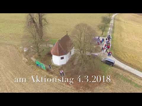 The Jöhlingen civic initiative labels this short film a flight over the Maria-Hilf Chapel. The subject is a specific landmark above the village, built in 1732 and still associated with pilgrimages. The aerial angle complements a walking visit by placing the chapel in its wooded setting. It is a brief visual introduction, not a source for current access or pilgrimage dates.
 Oliver Hauska’s recording documents the procession held on 21 July 2024 for Jöhlingen and Wössingen’s thousand-year commemoration and the Jöhlingen volunteer fire brigade’s 150th anniversary. Its description names fire services, music groups, sports clubs and other local associations in the parade. The anniversary refers to the villages’ earliest written record in 1024; the present municipality itself was formed in 1971.