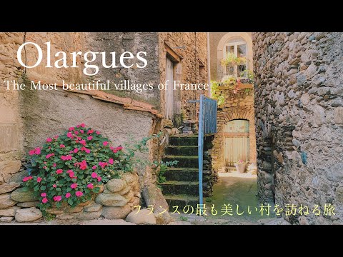
Olargues is built for a slow climb. The old settlement occupies a rocky rise almost wrapped by a bend of the Jaur, with the river crossing at the Pont Vieux below and the former castrum above. Lanes climb through stone houses, narrow passages and calades, the sloping paths paved with rounded stones. At the top, a tower now used as a church bell tower looks toward the Caroux and Espinouse ranges. The whole route from river level to the castrum gains more than seventy metres, so the village is best approached on foot and without a rushed timetable.
The municipality counted 488 residents in 2023, according to INSEE; that figure covers the whole commune, not only the compact old village. Olargues lies in the Haut-Languedoc Regional Natural Park in the Hérault department of Occitanie. Its position between mountain country and the lower Mediterranean hinterland shaped its historic connections and still gives visitors a choice between architecture, regional food, cycling and walking. It is one of the villages recognised by the association Les Plus Beaux Villages de France, but its appeal is not only visual: the old bridge, museum and paths explain how people have used this valley.
A medieval new town above older traces
The evidence points to a medieval fortified town, not a proven Roman foundation. A regional heritage walk dates the castrum to 1127 and presents Olargues as a twelfth-century new town developed around a stronghold. Excavations at the castle site between 1999 and 2004 supplied objects now shown in the local museum and helped clarify how the settlement was organised. A charter of liberties granted to the town and lordship in 1289 is another firm marker in its civic history. The wider Jaur valley has much older traces: the municipal heritage account identifies prehistoric engravings at Peyro Escrito and other remains in the surrounding area. Those finds show ancient human presence in the region; they do not prove that the present village existed in Roman times.
The castle once occupied the rocky summit, with a church, lordly residences, workshops and shared ovens within the fortified area. The stronghold was later abandoned and largely dismantled; its surviving tower was adapted as a bell tower in the seventeenth century. Downhill, the present church of Saint-Laurent and its Clergeau organ connect the old settlement to later religious and musical life. The walk between them is a lesson in how the town changed: the steep topography that once helped defend the castrum now shapes the visitor’s route and the views from each landing.
The bridge, its history and its devil
The Pont Vieux, better known as the Pont du Diable, is the village’s most striking piece of engineering. Hérault’s heritage itinerary dates it to around 1150 and says it was inaugurated in 1160. Its high stone arch carries the road across the Jaur and once formed part of an important east–west route through the uplands. The bridge is protected as a historic monument. Look at it from the riverbanks as well as from the crossing: from below, its single broad arch and the tight bend of the valley become easier to read together.
The devil attached to the bridge belongs to folklore, not to its construction record. A study published by the Haut-Languedoc regional park records the local version: repeated floods supposedly destroyed the villagers’ work; the devil offered to finish the bridge in return for the first soul to cross it; the villagers sent a goat, and the devil vanished with the animal. The tale gives a dramatic name to a difficult building project, while the bridge’s medieval date and the regional route explain its practical importance. Keeping the legend in its proper place makes the story more interesting, not less.
What the museum preserves
Climb the Escalier de la Commanderie to the Musée d’Arts et Traditions Populaires, housed in the old village. Created in 1989 by the municipality and residents, it occupies about 300 square metres across eight rooms and three levels. The displays bring together agricultural tools, workshop models, schoolwork, family photographs and geological specimens gathered nearby. They document activities remembered locally: ploughing, wine-growing, wheat, chestnuts, cherries and honey, alongside the work of blacksmiths, toolmakers, shoemakers and laundresses. This is useful context for reading the lanes as a lived settlement rather than a preserved stage set.
One room presents material from the castrum excavations, linking objects to the town’s medieval development. The museum is free to enter, with donations welcomed, and its municipal page lists a seasonal opening period from May through September, Tuesday to Sunday, 15:00–18:30. Hours and guided visits can change, so check before making a special trip. The same site lists local shops, places to eat and accommodation; these services matter in a small village where some businesses adjust their schedules to the season.
Chestnuts, crafts and life today
Olargues is often associated with chestnuts, and the connection is more than a menu item. Hérault Tourism describes chestnut cultivation as an important part of the rural economy of the Jaur valley; until the late nineteenth century, chestnut flour was a staple and earned the tree its local reputation as a bread tree. Museum displays also recall the harvest alongside vineyards, cherries and honey. Today’s municipal directory shows a mix of food shops, cafés and restaurants, guest accommodation, artisans and small creative businesses. Those listings are practical rather than a complete economic census: they indicate what visitors may find in town, while opening and availability should be checked directly.
The Centre Cebenna adds a different kind of local service. This environmental education association organises nature outings and learning activities across the Haut-Languedoc, including guided discovery walks, geology, night-sky events and opportunities to observe wildlife. Sightings of wild animals can never be guaranteed, and activities depend on the calendar and conditions. For visitors, Cebenna is a way to understand the landscape with local guidance instead of treating the mountains as scenery alone.
Walks and rides into the Caroux
Olargues is a useful base for outdoor routes. The Passa Païs greenway follows a former railway alignment for roughly eighty kilometres between Bédarieux and Mazamet, crossing the village on a metal railway bridge over the Jaur. Its gentle gradients make it a different experience from the steep lanes of the old centre, and cyclists can choose a short out-and-back section or a longer journey across the Haut-Languedoc. The route connects Mediterranean-facing country with the region’s Atlantic-facing slopes; check the official route information for surface conditions and access before setting off.
For walkers, marked paths lead into the Caroux and Espinouse landscapes. Hérault Tourism highlights the viewpoint from Pic de Naudech toward Vieussan and the waterfalls around Mauroul; some routes are strenuous, and the terrain changes with weather. Nearby settlements such as Mons-la-Trivalle and Saint-Pons-de-Thomières offer additional stops along the valley. A good day can combine the old village, the museum and a short section of the greenway, leaving a separate visit for a mountain walk rather than trying to fit every landscape into one afternoon.
Getting there and planning a visit
Hérault Transport lists lines 682 and 685 along the corridor linking Montpellier’s Station Mosson, Gignac, Clermont-l’Hérault, Bédarieux, Lamalou-les-Bains, Olargues and Saint-Pons-de-Thomières. The combined route page does not mean every departure serves every stop in the same way; check the current timetable and any connection before travelling, especially on weekends and outside school periods. The former railway is now a greenway, so do not plan on reaching Olargues by train. By car, the village lies on the valley road between Bédarieux and Saint-Pons; once there, allow time for narrow streets, steps and the climb to the tower.
Olargues rewards visitors who pair its famous bridge with the less obvious details: the museum’s family photographs, the old street grades, the remains of the castrum and the changing light over the Jaur. It is also a practical stop for food, a night in the valley or a day on Passa Païs. Confirm transport, museum hours, guided walks, business openings and trail conditions before departure. The town’s own steepness, small scale and seasonal rhythm are part of the visit, and planning around them helps the place reveal more than its postcard view.
 Olargues on foot: lanes, views and the Passa Païs
 A family outing on the Passa Païs
Produced under the Plaisirs d’Hérault tourism identity, this short film broadens the view from the medieval core to the greenway landscape around Olargues. The Passa Païs uses a former railway corridor and crosses the Jaur near the village on a metal bridge; the video is useful for imagining a relaxed family-scale outing on this route. It should be treated as an introduction to the outdoor experience, not as a live trail report: check current access, surface conditions and services before setting out.
A family outing on the Passa Païs
Produced under the Plaisirs d’Hérault tourism identity, this short film broadens the view from the medieval core to the greenway landscape around Olargues. The Passa Païs uses a former railway corridor and crosses the Jaur near the village on a metal bridge; the video is useful for imagining a relaxed family-scale outing on this route. It should be treated as an introduction to the outdoor experience, not as a live trail report: check current access, surface conditions and services before setting out.
 Olargues Village Médiéval
Mes randos presents Olargues as a perched, formerly fortified village in the Haut-Languedoc, with the Caroux as its mountain backdrop. The concise film is a good companion to the autumn walk because it draws attention to the village’s built form and outlook rather than the regional cycling route. Its description is brief and promotional; use the images to orient yourself, then rely on the municipal museum and heritage trail for dates, interpretation and practical details.
Olargues Village Médiéval
Mes randos presents Olargues as a perched, formerly fortified village in the Haut-Languedoc, with the Caroux as its mountain backdrop. The concise film is a good companion to the autumn walk because it draws attention to the village’s built form and outlook rather than the regional cycling route. Its description is brief and promotional; use the images to orient yourself, then rely on the municipal museum and heritage trail for dates, interpretation and practical details.